You are here: Home > Network List > TA - USArray Transportable Network (new EarthScope stations) Stations List
> Station C31A Landman Farms, Northwood, ND, USA > Earthquake Result Viewer
C31A Landman Farms, Northwood, ND, USA - Earthquake Result Viewer
| Earthquake location: |
Near Coast Of Central Chile |
| Earthquake latitude/longitude: |
-37.6/-73.7 |
| Earthquake time(UTC): |
2011/06/01 (152) 12:55:22 GMT |
| Earthquake Depth: |
21 km |
| Earthquake Magnitude: |
5.6 MB, 6.2 MS, 6.3 MW, 6.3 MW |
| Earthquake Catalog/Contributor: |
WHDF/NEIC |
|
| Network: |
TA USArray Transportable Network (new EarthScope stations) |
| Station: |
C31A Landman Farms, Northwood, ND, USA |
| Lat/Lon: |
47.79 N/97.73 W |
| Elevation: |
384 m |
|
| Distance: |
87.7 deg |
| Az: |
344.041 deg |
| Baz: |
161.097 deg |
| Ray Param: |
0.04314414 |
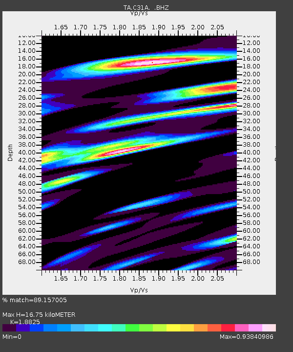
| Estimated Moho Depth: |
16.75 km |
| Estimated Crust Vp/Vs: |
1.88 |
| Assumed Crust Vp: |
6.498 km/s |
| Estimated Crust Vs: |
3.452 km/s |
| Estimated Crust Poisson's Ratio: |
0.30 |
|
| Radial Match: |
89.157005 % |
| Radial Bump: |
400 |
| Transverse Match: |
70.748924 % |
| Transverse Bump: |
400 |
| SOD ConfigId: |
393008 |
| Insert Time: |
2011-11-01 00:08:05.431 +0000 |
| GWidth: |
2.5 |
| Max Bumps: |
400 |
| Tol: |
0.001 |
|

Signal To Noise
| Channel | StoN | STA | LTA |
| TA:C31A: :BHZ:20110601T13:07:37.724971Z | 4.4189425 | 4.4399286E-7 | 1.00474914E-7 |
| TA:C31A: :BHN:20110601T13:07:37.724971Z | 1.0938852 | 1.7014979E-7 | 1.555463E-7 |
| TA:C31A: :BHE:20110601T13:07:37.724971Z | 1.2321775 | 1.6220737E-7 | 1.3164286E-7 |
| Arrivals |
| Ps | 2.3 SECOND |
| PpPs | 7.3 SECOND |
| PsPs/PpSs | 9.6 SECOND |


