You are here: Home > Network List > TA - USArray Transportable Network (new EarthScope stations) Stations List
> Station E34A Wadena, MN, USA > Earthquake Result Viewer
E34A Wadena, MN, USA - Earthquake Result Viewer

| Earthquake location: |
Near Coast Of Central Chile |
| Earthquake latitude/longitude: |
-37.6/-73.7 |
| Earthquake time(UTC): |
2011/06/01 (152) 12:55:22 GMT |
| Earthquake Depth: |
21 km |
| Earthquake Magnitude: |
5.6 MB, 6.2 MS, 6.3 MW, 6.3 MW |
| Earthquake Catalog/Contributor: |
WHDF/NEIC |
|
| Network: |
TA USArray Transportable Network (new EarthScope stations) |
| Station: |
E34A Wadena, MN, USA |
| Lat/Lon: |
46.51 N/95.17 W |
| Elevation: |
430 m |
|
| Distance: |
85.9 deg |
| Az: |
345.315 deg |
| Baz: |
163.043 deg |
| Ray Param: |
0.044410575 |
| Estimated Moho Depth: |
45.5 km |
| Estimated Crust Vp/Vs: |
1.71 |
| Assumed Crust Vp: |
6.419 km/s |
| Estimated Crust Vs: |
3.748 km/s |
| Estimated Crust Poisson's Ratio: |
0.24 |
|
| Radial Match: |
85.30724 % |
| Radial Bump: |
400 |
| Transverse Match: |
55.17003 % |
| Transverse Bump: |
400 |
| SOD ConfigId: |
393008 |
| Insert Time: |
2011-11-01 00:08:35.038 +0000 |
| GWidth: |
2.5 |
| Max Bumps: |
400 |
| Tol: |
0.001 |
|
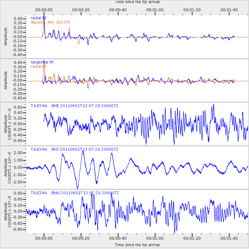
Signal To Noise
| Channel | StoN | STA | LTA |
| TA:E34A: :BHZ:20110601T13:07:29.200007Z | 3.806668 | 3.28517E-7 | 8.6300396E-8 |
| TA:E34A: :BHN:20110601T13:07:29.200007Z | 1.043973 | 1.2687731E-7 | 1.2153315E-7 |
| TA:E34A: :BHE:20110601T13:07:29.200007Z | 0.65976477 | 1.1803648E-7 | 1.7890692E-7 |
| Arrivals |
| Ps | 5.2 SECOND |
| PpPs | 19 SECOND |
| PsPs/PpSs | 24 SECOND |


