You are here: Home > Network List > TA - USArray Transportable Network (new EarthScope stations) Stations List
> Station G35A Watkins, MN, USA > Earthquake Result Viewer
G35A Watkins, MN, USA - Earthquake Result Viewer
| Earthquake location: |
Near Coast Of Central Chile |
| Earthquake latitude/longitude: |
-37.6/-73.7 |
| Earthquake time(UTC): |
2011/06/01 (152) 12:55:22 GMT |
| Earthquake Depth: |
21 km |
| Earthquake Magnitude: |
5.6 MB, 6.2 MS, 6.3 MW, 6.3 MW |
| Earthquake Catalog/Contributor: |
WHDF/NEIC |
|
| Network: |
TA USArray Transportable Network (new EarthScope stations) |
| Station: |
G35A Watkins, MN, USA |
| Lat/Lon: |
45.22 N/94.49 W |
| Elevation: |
361 m |
|
| Distance: |
84.5 deg |
| Az: |
345.4 deg |
| Baz: |
163.54 deg |
| Ray Param: |
0.04539788 |
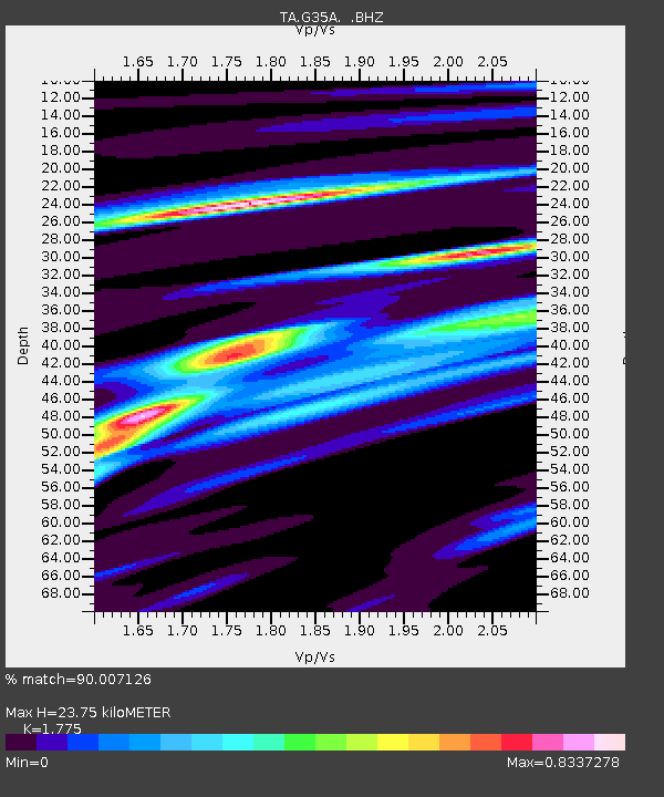
| Estimated Moho Depth: |
23.75 km |
| Estimated Crust Vp/Vs: |
1.77 |
| Assumed Crust Vp: |
6.571 km/s |
| Estimated Crust Vs: |
3.702 km/s |
| Estimated Crust Poisson's Ratio: |
0.27 |
|
| Radial Match: |
90.007126 % |
| Radial Bump: |
400 |
| Transverse Match: |
66.00578 % |
| Transverse Bump: |
400 |
| SOD ConfigId: |
393008 |
| Insert Time: |
2011-11-01 00:09:45.490 +0000 |
| GWidth: |
2.5 |
| Max Bumps: |
400 |
| Tol: |
0.001 |
|
Signal To Noise
| Channel | StoN | STA | LTA |
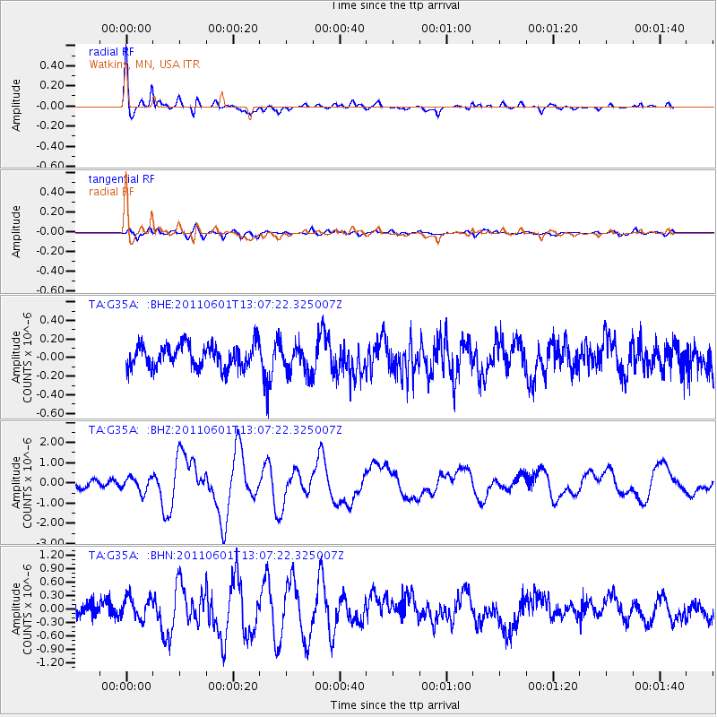
| TA:G35A: :BHZ:20110601T13:07:22.325007Z | 2.3469179 | 3.5835362E-7 | 1.5269116E-7 |
| TA:G35A: :BHN:20110601T13:07:22.325007Z | 1.8738959 | 2.4737895E-7 | 1.3201317E-7 |
| TA:G35A: :BHE:20110601T13:07:22.325007Z | 1.2305932 | 1.5204881E-7 | 1.2355734E-7 |
| Arrivals |
| Ps | 2.9 SECOND |
| PpPs | 9.8 SECOND |
| PsPs/PpSs | 13 SECOND |


