You are here: Home > Network List > TA - USArray Transportable Network (new EarthScope stations) Stations List
> Station G33A Ortonville, MN, USA > Earthquake Result Viewer
G33A Ortonville, MN, USA - Earthquake Result Viewer
| Earthquake location: |
Near Coast Of Central Chile |
| Earthquake latitude/longitude: |
-37.6/-73.7 |
| Earthquake time(UTC): |
2011/06/01 (152) 12:55:22 GMT |
| Earthquake Depth: |
21 km |
| Earthquake Magnitude: |
5.6 MB, 6.2 MS, 6.3 MW, 6.3 MW |
| Earthquake Catalog/Contributor: |
WHDF/NEIC |
|
| Network: |
TA USArray Transportable Network (new EarthScope stations) |
| Station: |
G33A Ortonville, MN, USA |
| Lat/Lon: |
45.19 N/96.44 W |
| Elevation: |
338 m |
|
| Distance: |
84.9 deg |
| Az: |
344.069 deg |
| Baz: |
162.036 deg |
| Ray Param: |
0.04512168 |
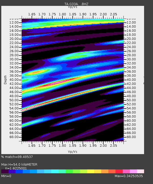
| Estimated Moho Depth: |
54.0 km |
| Estimated Crust Vp/Vs: |
1.62 |
| Assumed Crust Vp: |
6.552 km/s |
| Estimated Crust Vs: |
4.038 km/s |
| Estimated Crust Poisson's Ratio: |
0.19 |
|
| Radial Match: |
89.48537 % |
| Radial Bump: |
400 |
| Transverse Match: |
67.10823 % |
| Transverse Bump: |
400 |
| SOD ConfigId: |
393008 |
| Insert Time: |
2011-11-01 00:10:37.276 +0000 |
| GWidth: |
2.5 |
| Max Bumps: |
400 |
| Tol: |
0.001 |
|

Signal To Noise
| Channel | StoN | STA | LTA |
| TA:G33A: :BHZ:20110601T13:07:24.27502Z | 3.7014854 | 3.7609854E-7 | 1.0160746E-7 |
| TA:G33A: :BHN:20110601T13:07:24.27502Z | 1.6043017 | 1.8607301E-7 | 1.159838E-7 |
| TA:G33A: :BHE:20110601T13:07:24.27502Z | 0.96610796 | 1.12393835E-7 | 1.1633672E-7 |
| Arrivals |
| Ps | 5.3 SECOND |
| PpPs | 21 SECOND |
| PsPs/PpSs | 26 SECOND |


