You are here: Home > Network List > TA - USArray Transportable Network (new EarthScope stations) Stations List
> Station K37A Belmond, IA, USA > Earthquake Result Viewer
K37A Belmond, IA, USA - Earthquake Result Viewer
| Earthquake location: |
Near Coast Of Central Chile |
| Earthquake latitude/longitude: |
-37.6/-73.7 |
| Earthquake time(UTC): |
2011/06/01 (152) 12:55:22 GMT |
| Earthquake Depth: |
21 km |
| Earthquake Magnitude: |
5.6 MB, 6.2 MS, 6.3 MW, 6.3 MW |
| Earthquake Catalog/Contributor: |
WHDF/NEIC |
|
| Network: |
TA USArray Transportable Network (new EarthScope stations) |
| Station: |
K37A Belmond, IA, USA |
| Lat/Lon: |
42.77 N/93.64 W |
| Elevation: |
365 m |
|
| Distance: |
82.0 deg |
| Az: |
345.304 deg |
| Baz: |
164.115 deg |
| Ray Param: |
0.047168974 |
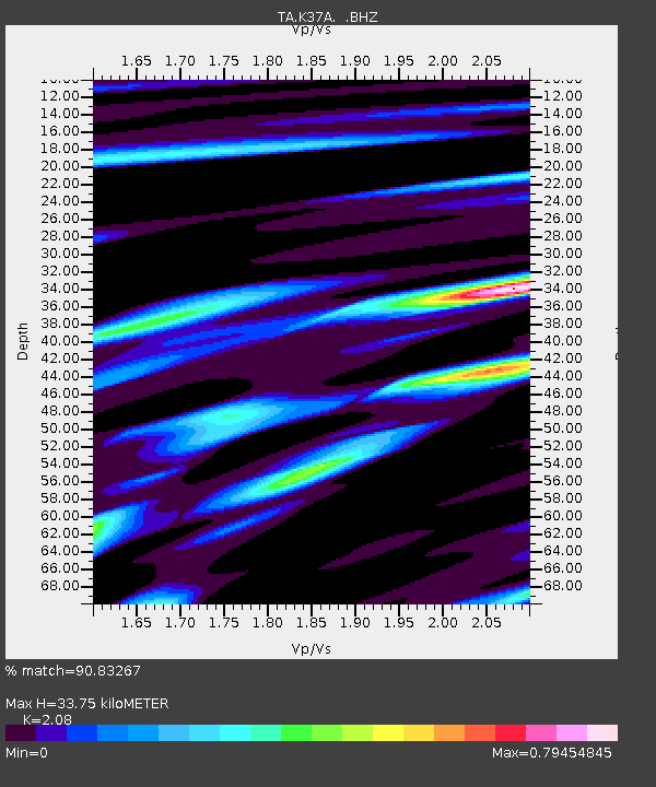
| Estimated Moho Depth: |
33.75 km |
| Estimated Crust Vp/Vs: |
2.08 |
| Assumed Crust Vp: |
6.53 km/s |
| Estimated Crust Vs: |
3.14 km/s |
| Estimated Crust Poisson's Ratio: |
0.35 |
|
| Radial Match: |
90.83267 % |
| Radial Bump: |
400 |
| Transverse Match: |
65.34427 % |
| Transverse Bump: |
400 |
| SOD ConfigId: |
393008 |
| Insert Time: |
2011-11-01 00:11:07.278 +0000 |
| GWidth: |
2.5 |
| Max Bumps: |
400 |
| Tol: |
0.001 |
|

Signal To Noise
| Channel | StoN | STA | LTA |
| TA:K37A: :BHZ:20110601T13:07:09.374995Z | 2.8495433 | 2.5967958E-7 | 9.113024E-8 |
| TA:K37A: :BHN:20110601T13:07:09.374995Z | 1.2511425 | 1.557297E-7 | 1.2446998E-7 |
| TA:K37A: :BHE:20110601T13:07:09.374995Z | 1.3091688 | 1.734191E-7 | 1.3246503E-7 |
| Arrivals |
| Ps | 5.7 SECOND |
| PpPs | 16 SECOND |
| PsPs/PpSs | 21 SECOND |


