You are here: Home > Network List > TA - USArray Transportable Network (new EarthScope stations) Stations List
> Station E36A McGregor, MN, USA > Earthquake Result Viewer
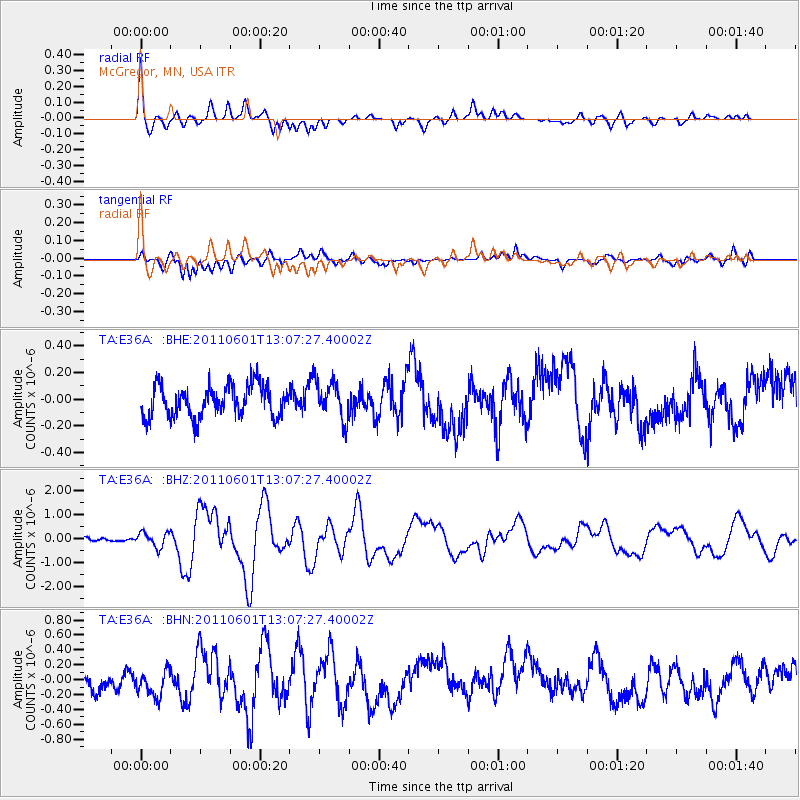
E36A McGregor, MN, USA - Earthquake Result Viewer
*The percent match for this event was below the threshold and hence no stack was calculated.
| Earthquake location: |
Near Coast Of Central Chile |
| Earthquake latitude/longitude: |
-37.6/-73.7 |
| Earthquake time(UTC): |
2011/06/01 (152) 12:55:22 GMT |
| Earthquake Depth: |
21 km |
| Earthquake Magnitude: |
5.6 MB, 6.2 MS, 6.3 MW, 6.3 MW |
| Earthquake Catalog/Contributor: |
WHDF/NEIC |
|
| Network: |
TA USArray Transportable Network (new EarthScope stations) |
| Station: |
E36A McGregor, MN, USA |
| Lat/Lon: |
46.52 N/93.26 W |
| Elevation: |
393 m |
|
| Distance: |
85.5 deg |
| Az: |
346.588 deg |
| Baz: |
164.522 deg |
| Ray Param: |
$rayparam |
*The percent match for this event was below the threshold and hence was not used in the summary stack. |
|
| Radial Match: |
77.088326 % |
| Radial Bump: |
400 |
| Transverse Match: |
74.59098 % |
| Transverse Bump: |
400 |
| SOD ConfigId: |
393008 |
| Insert Time: |
2011-11-01 00:11:21.015 +0000 |
| GWidth: |
2.5 |
| Max Bumps: |
400 |
| Tol: |
0.001 |
|
Signal To Noise
| Channel | StoN | STA | LTA |
| TA:E36A: :BHZ:20110601T13:07:27.40002Z | 3.4748375 | 3.078091E-7 | 8.8582304E-8 |
| TA:E36A: :BHN:20110601T13:07:27.40002Z | 1.3517984 | 1.7797802E-7 | 1.3166017E-7 |
| TA:E36A: :BHE:20110601T13:07:27.40002Z | 1.2351567 | 1.4262476E-7 | 1.1547099E-7 |
| Arrivals |
| Ps | |
| PpPs | |
| PsPs/PpSs | |


