You are here: Home > Network List > TA - USArray Transportable Network (new EarthScope stations) Stations List
> Station N36A Muff Farm, Clarinda, IA, USA > Earthquake Result Viewer
N36A Muff Farm, Clarinda, IA, USA - Earthquake Result Viewer
| Earthquake location: |
Near Coast Of Central Chile |
| Earthquake latitude/longitude: |
-37.6/-73.7 |
| Earthquake time(UTC): |
2011/06/01 (152) 12:55:22 GMT |
| Earthquake Depth: |
21 km |
| Earthquake Magnitude: |
5.6 MB, 6.2 MS, 6.3 MW, 6.3 MW |
| Earthquake Catalog/Contributor: |
WHDF/NEIC |
|
| Network: |
TA USArray Transportable Network (new EarthScope stations) |
| Station: |
N36A Muff Farm, Clarinda, IA, USA |
| Lat/Lon: |
40.82 N/94.96 W |
| Elevation: |
349 m |
|
| Distance: |
80.4 deg |
| Az: |
343.786 deg |
| Baz: |
163.005 deg |
| Ray Param: |
0.048273176 |
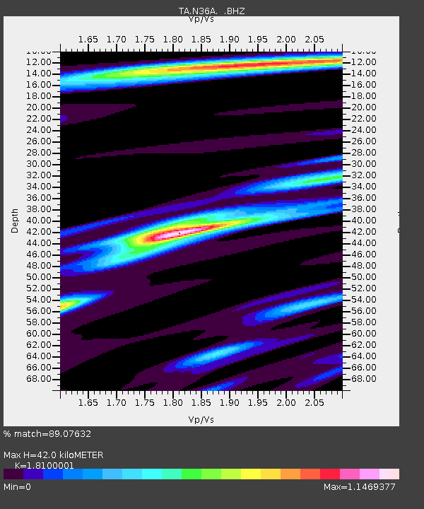
| Estimated Moho Depth: |
42.0 km |
| Estimated Crust Vp/Vs: |
1.81 |
| Assumed Crust Vp: |
6.498 km/s |
| Estimated Crust Vs: |
3.59 km/s |
| Estimated Crust Poisson's Ratio: |
0.28 |
|
| Radial Match: |
89.07632 % |
| Radial Bump: |
400 |
| Transverse Match: |
65.21039 % |
| Transverse Bump: |
400 |
| SOD ConfigId: |
393008 |
| Insert Time: |
2011-11-01 00:13:03.700 +0000 |
| GWidth: |
2.5 |
| Max Bumps: |
400 |
| Tol: |
0.001 |
|

Signal To Noise
| Channel | StoN | STA | LTA |
| TA:N36A: :BHZ:20110601T13:07:00.950007Z | 3.0645485 | 3.7360581E-7 | 1.2191218E-7 |
| TA:N36A: :BHN:20110601T13:07:00.950007Z | 1.1153116 | 1.9200681E-7 | 1.721553E-7 |
| TA:N36A: :BHE:20110601T13:07:00.950007Z | 0.6828722 | 9.995827E-8 | 1.463792E-7 |
| Arrivals |
| Ps | 5.4 SECOND |
| PpPs | 18 SECOND |
| PsPs/PpSs | 23 SECOND |


