You are here: Home > Network List > TA - USArray Transportable Network (new EarthScope stations) Stations List
> Station W37B Quinton, OK, USA > Earthquake Result Viewer
W37B Quinton, OK, USA - Earthquake Result Viewer
| Earthquake location: |
Near Coast Of Central Chile |
| Earthquake latitude/longitude: |
-37.6/-73.7 |
| Earthquake time(UTC): |
2011/06/01 (152) 12:55:22 GMT |
| Earthquake Depth: |
21 km |
| Earthquake Magnitude: |
5.6 MB, 6.2 MS, 6.3 MW, 6.3 MW |
| Earthquake Catalog/Contributor: |
WHDF/NEIC |
|
| Network: |
TA USArray Transportable Network (new EarthScope stations) |
| Station: |
W37B Quinton, OK, USA |
| Lat/Lon: |
35.14 N/95.43 W |
| Elevation: |
279 m |
|
| Distance: |
75.1 deg |
| Az: |
341.693 deg |
| Baz: |
162.272 deg |
| Ray Param: |
0.051862124 |
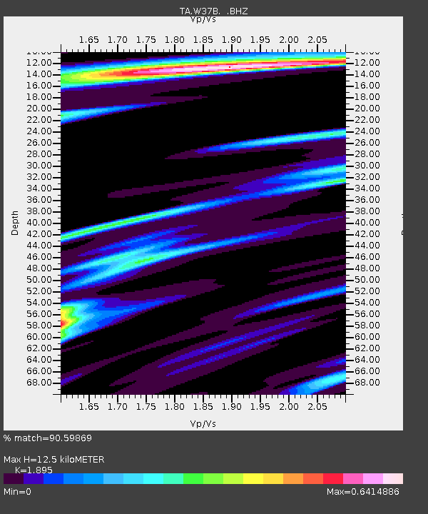
| Estimated Moho Depth: |
12.5 km |
| Estimated Crust Vp/Vs: |
1.89 |
| Assumed Crust Vp: |
6.498 km/s |
| Estimated Crust Vs: |
3.429 km/s |
| Estimated Crust Poisson's Ratio: |
0.31 |
|
| Radial Match: |
90.59869 % |
| Radial Bump: |
384 |
| Transverse Match: |
83.42635 % |
| Transverse Bump: |
400 |
| SOD ConfigId: |
393008 |
| Insert Time: |
2011-11-01 00:15:25.270 +0000 |
| GWidth: |
2.5 |
| Max Bumps: |
400 |
| Tol: |
0.001 |
|
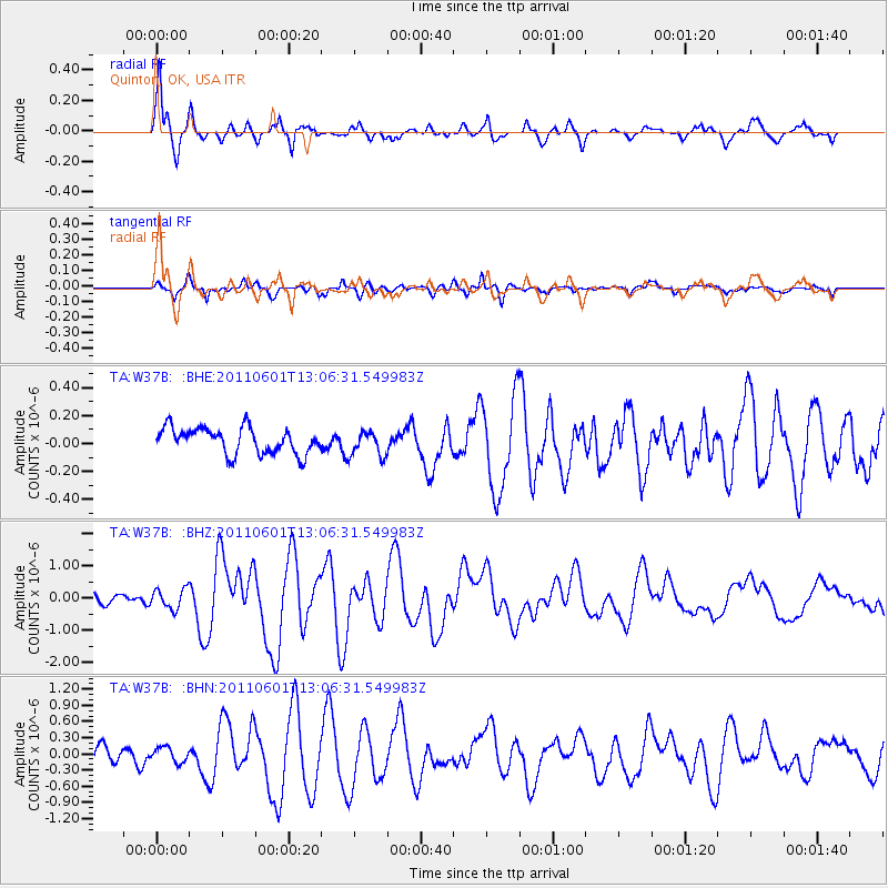
Signal To Noise
| Channel | StoN | STA | LTA |
| TA:W37B: :BHZ:20110601T13:06:31.549983Z | 2.6282187 | 3.1169967E-7 | 1.18597306E-7 |
| TA:W37B: :BHN:20110601T13:06:31.549983Z | 0.69436646 | 1.3829757E-7 | 1.9917087E-7 |
| TA:W37B: :BHE:20110601T13:06:31.549983Z | 0.97546303 | 8.98089E-8 | 9.206797E-8 |
| Arrivals |
| Ps | 1.8 SECOND |
| PpPs | 5.4 SECOND |
| PsPs/PpSs | 7.2 SECOND |


