You are here: Home > Network List > TA - USArray Transportable Network (new EarthScope stations) Stations List
> Station W39A Magazine, AR, USA > Earthquake Result Viewer
W39A Magazine, AR, USA - Earthquake Result Viewer
| Earthquake location: |
Near Coast Of Central Chile |
| Earthquake latitude/longitude: |
-37.6/-73.7 |
| Earthquake time(UTC): |
2011/06/01 (152) 12:55:22 GMT |
| Earthquake Depth: |
21 km |
| Earthquake Magnitude: |
5.6 MB, 6.2 MS, 6.3 MW, 6.3 MW |
| Earthquake Catalog/Contributor: |
WHDF/NEIC |
|
| Network: |
TA USArray Transportable Network (new EarthScope stations) |
| Station: |
W39A Magazine, AR, USA |
| Lat/Lon: |
35.20 N/93.78 W |
| Elevation: |
162 m |
|
| Distance: |
74.8 deg |
| Az: |
343.046 deg |
| Baz: |
163.568 deg |
| Ray Param: |
0.052086998 |
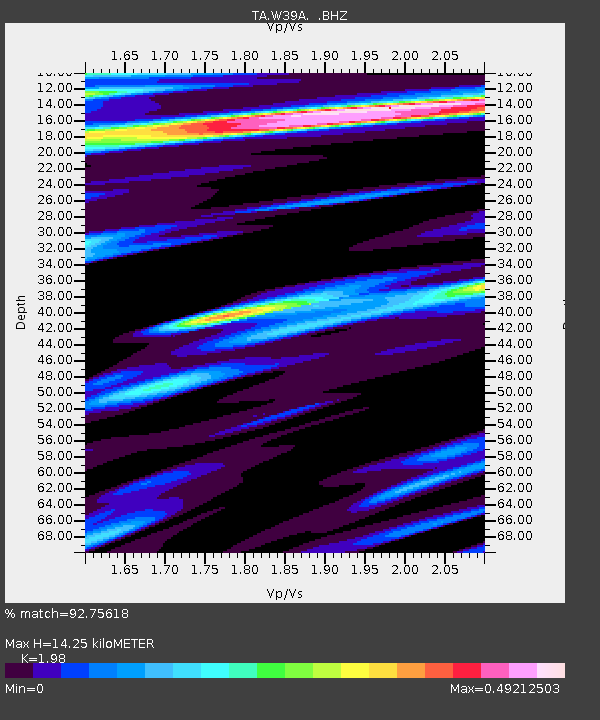
| Estimated Moho Depth: |
14.25 km |
| Estimated Crust Vp/Vs: |
1.98 |
| Assumed Crust Vp: |
6.498 km/s |
| Estimated Crust Vs: |
3.282 km/s |
| Estimated Crust Poisson's Ratio: |
0.33 |
|
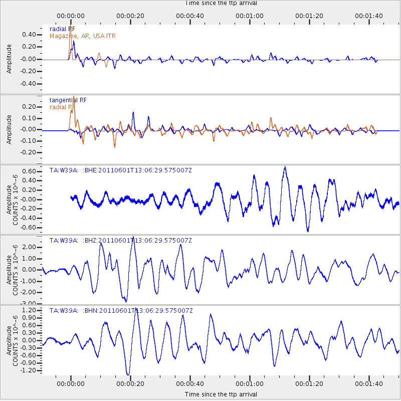
| Radial Match: |
92.75618 % |
| Radial Bump: |
381 |
| Transverse Match: |
91.68897 % |
| Transverse Bump: |
399 |
| SOD ConfigId: |
393008 |
| Insert Time: |
2011-11-01 00:15:39.690 +0000 |
| GWidth: |
2.5 |
| Max Bumps: |
400 |
| Tol: |
0.001 |
|
Signal To Noise
| Channel | StoN | STA | LTA |
| TA:W39A: :BHZ:20110601T13:06:29.575007Z | 2.406541 | 3.9438507E-7 | 1.6388047E-7 |
| TA:W39A: :BHN:20110601T13:06:29.575007Z | 1.9274502 | 1.8070213E-7 | 9.375191E-8 |
| TA:W39A: :BHE:20110601T13:06:29.575007Z | 1.2643102 | 9.731759E-8 | 7.6972874E-8 |
| Arrivals |
| Ps | 2.2 SECOND |
| PpPs | 6.3 SECOND |
| PsPs/PpSs | 8.6 SECOND |


