KMI Kunming, Yunnan Province, China - Earthquake Result Viewer
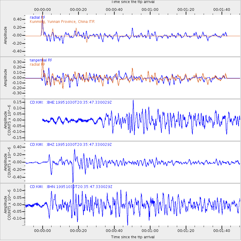
Earthquake location: Andreanof Islands, Aleutian Is.
Earthquake latitude/longitude: 51.7/-173.4
Earthquake time(UTC): 1995/10/30 (303) 20:25:28 GMT
Earthquake Depth: 33 km
Earthquake Magnitude: 5.4 MB, 5.3 MS, 5.8 UNKNOWN, 5.6 ML
Earthquake Catalog/Contributor: WHDF/NEIC
Network: CD China Digital Seismograph Network
Station: KMI Kunming, Yunnan Province, China
Lat/Lon: 25.12 N/102.74 E
Elevation: 1975 m
Distance: 67.0 deg
Az: 281.69 deg
Baz: 42.26 deg
Ray Param: 0.057209443
Estimated Moho Depth: 42.5 km
Estimated Crust Vp/Vs: 1.77
Assumed Crust Vp: 6.247 km/s
Estimated Crust Vs: 3.519 km/s
Estimated Crust Poisson's Ratio: 0.27
Radial Match: 82.33165 %
Radial Bump: 400
Transverse Match: 82.38209 %
Transverse Bump: 400
SOD ConfigId: 4480
Insert Time: 2010-02-26 21:21:30.589 +0000
GWidth: 2.5
Max Bumps: 400
Tol: 0.001

Signal To Noise

ChannelStoNSTALTA
CD:KMI: :BHZ:19951030T20:35:47.330029Z9.00221359.1084324E-81.0117993E-8
CD:KMI: :BHN:19951030T20:35:47.330029Z5.4266613.313414E-86.105806E-9
CD:KMI: :BHE:19951030T20:35:47.330029Z2.11075022.5297078E-81.1984875E-8
Arrivals
Ps5.5 SECOND
PpPs18 SECOND
PsPs/PpSs24 SECOND