You are here: Home > Network List > TA - USArray Transportable Network (new EarthScope stations) Stations List
> Station 248A Dixon Mills, AL, USA > Earthquake Result Viewer
248A Dixon Mills, AL, USA - Earthquake Result Viewer
| Earthquake location: |
Near Coast Of Central Chile |
| Earthquake latitude/longitude: |
-37.6/-73.7 |
| Earthquake time(UTC): |
2011/06/01 (152) 12:55:22 GMT |
| Earthquake Depth: |
21 km |
| Earthquake Magnitude: |
5.6 MB, 6.2 MS, 6.3 MW, 6.3 MW |
| Earthquake Catalog/Contributor: |
WHDF/NEIC |
|
| Network: |
TA USArray Transportable Network (new EarthScope stations) |
| Station: |
248A Dixon Mills, AL, USA |
| Lat/Lon: |
32.09 N/87.74 W |
| Elevation: |
103 m |
|
| Distance: |
70.5 deg |
| Az: |
347.378 deg |
| Baz: |
168.198 deg |
| Ray Param: |
0.054890603 |
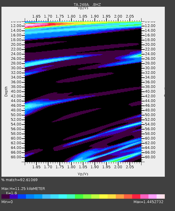
| Estimated Moho Depth: |
11.25 km |
| Estimated Crust Vp/Vs: |
1.60 |
| Assumed Crust Vp: |
6.565 km/s |
| Estimated Crust Vs: |
4.103 km/s |
| Estimated Crust Poisson's Ratio: |
0.18 |
|
| Radial Match: |
92.61069 % |
| Radial Bump: |
400 |
| Transverse Match: |
84.16975 % |
| Transverse Bump: |
400 |
| SOD ConfigId: |
393008 |
| Insert Time: |
2011-11-01 00:17:53.812 +0000 |
| GWidth: |
2.5 |
| Max Bumps: |
400 |
| Tol: |
0.001 |
|

Signal To Noise
| Channel | StoN | STA | LTA |
| TA:248A: :BHZ:20110601T13:06:04.499995Z | 3.6619442 | 7.4686676E-7 | 2.039536E-7 |
| TA:248A: :BHN:20110601T13:06:04.499995Z | 1.0976985 | 3.867026E-7 | 3.522849E-7 |
| TA:248A: :BHE:20110601T13:06:04.499995Z | 1.0974718 | 3.4852948E-7 | 3.1757486E-7 |
| Arrivals |
| Ps | 1.1 SECOND |
| PpPs | 4.3 SECOND |
| PsPs/PpSs | 5.3 SECOND |


