You are here: Home > Network List > TA - USArray Transportable Network (new EarthScope stations) Stations List
> Station Z47A Carrollton, AL, USA > Earthquake Result Viewer
Z47A Carrollton, AL, USA - Earthquake Result Viewer
| Earthquake location: |
Near Coast Of Central Chile |
| Earthquake latitude/longitude: |
-37.6/-73.7 |
| Earthquake time(UTC): |
2011/06/01 (152) 12:55:22 GMT |
| Earthquake Depth: |
21 km |
| Earthquake Magnitude: |
5.6 MB, 6.2 MS, 6.3 MW, 6.3 MW |
| Earthquake Catalog/Contributor: |
WHDF/NEIC |
|
| Network: |
TA USArray Transportable Network (new EarthScope stations) |
| Station: |
Z47A Carrollton, AL, USA |
| Lat/Lon: |
33.20 N/88.07 W |
| Elevation: |
65 m |
|
| Distance: |
71.7 deg |
| Az: |
347.33 deg |
| Baz: |
168.005 deg |
| Ray Param: |
0.054144826 |
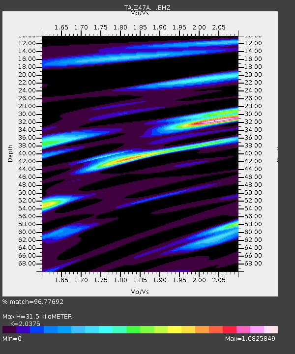
| Estimated Moho Depth: |
31.5 km |
| Estimated Crust Vp/Vs: |
2.04 |
| Assumed Crust Vp: |
6.201 km/s |
| Estimated Crust Vs: |
3.044 km/s |
| Estimated Crust Poisson's Ratio: |
0.34 |
|
| Radial Match: |
96.77692 % |
| Radial Bump: |
400 |
| Transverse Match: |
68.85807 % |
| Transverse Bump: |
400 |
| SOD ConfigId: |
393008 |
| Insert Time: |
2011-11-01 00:18:40.024 +0000 |
| GWidth: |
2.5 |
| Max Bumps: |
400 |
| Tol: |
0.001 |
|
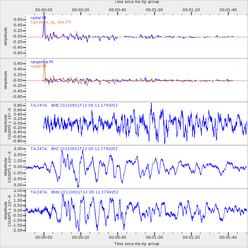
Signal To Noise
| Channel | StoN | STA | LTA |
| TA:Z47A: :BHZ:20110601T13:06:11.374995Z | 3.9658785 | 4.994606E-7 | 1.2593947E-7 |
| TA:Z47A: :BHN:20110601T13:06:11.374995Z | 2.1817532 | 2.986996E-7 | 1.3690806E-7 |
| TA:Z47A: :BHE:20110601T13:06:11.374995Z | 0.9926593 | 1.7032113E-7 | 1.7158067E-7 |
| Arrivals |
| Ps | 5.4 SECOND |
| PpPs | 15 SECOND |
| PsPs/PpSs | 20 SECOND |


