You are here: Home > Network List > TA - USArray Transportable Network (new EarthScope stations) Stations List
> Station X43A Marvell, AR, USA > Earthquake Result Viewer
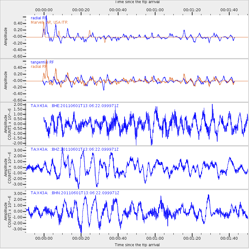
X43A Marvell, AR, USA - Earthquake Result Viewer
*The percent match for this event was below the threshold and hence no stack was calculated.
| Earthquake location: |
Near Coast Of Central Chile |
| Earthquake latitude/longitude: |
-37.6/-73.7 |
| Earthquake time(UTC): |
2011/06/01 (152) 12:55:22 GMT |
| Earthquake Depth: |
21 km |
| Earthquake Magnitude: |
5.6 MB, 6.2 MS, 6.3 MW, 6.3 MW |
| Earthquake Catalog/Contributor: |
WHDF/NEIC |
|
| Network: |
TA USArray Transportable Network (new EarthScope stations) |
| Station: |
X43A Marvell, AR, USA |
| Lat/Lon: |
34.52 N/90.88 W |
| Elevation: |
53 m |
|
| Distance: |
73.5 deg |
| Az: |
345.254 deg |
| Baz: |
165.824 deg |
| Ray Param: |
$rayparam |
*The percent match for this event was below the threshold and hence was not used in the summary stack. |
|
| Radial Match: |
85.59528 % |
| Radial Bump: |
297 |
| Transverse Match: |
62.115303 % |
| Transverse Bump: |
400 |
| SOD ConfigId: |
393008 |
| Insert Time: |
2011-11-01 00:19:39.831 +0000 |
| GWidth: |
2.5 |
| Max Bumps: |
400 |
| Tol: |
0.001 |
|
Signal To Noise
| Channel | StoN | STA | LTA |
| TA:X43A: :BHZ:20110601T13:06:22.099971Z | 2.7338343 | 7.343182E-7 | 2.6860374E-7 |
| TA:X43A: :BHN:20110601T13:06:22.099971Z | 0.9197409 | 4.3274582E-7 | 4.705084E-7 |
| TA:X43A: :BHE:20110601T13:06:22.099971Z | 0.89438576 | 4.974638E-7 | 5.562072E-7 |
| Arrivals |
| Ps | |
| PpPs | |
| PsPs/PpSs | |


