You are here: Home > Network List > CD - China Digital Seismograph Network Stations List
> Station KMI Kunming, Yunnan Province, China > Earthquake Result Viewer
KMI Kunming, Yunnan Province, China - Earthquake Result Viewer
| Earthquake location: |
Halmahera, Indonesia |
| Earthquake latitude/longitude: |
1.3/129.3 |
| Earthquake time(UTC): |
1992/09/27 (271) 10:04:39 GMT |
| Earthquake Depth: |
27 km |
| Earthquake Magnitude: |
5.3 MB, 5.8 MS |
| Earthquake Catalog/Contributor: |
WHDF/NEIC |
|
| Network: |
CD China Digital Seismograph Network |
| Station: |
KMI Kunming, Yunnan Province, China |
| Lat/Lon: |
25.12 N/102.74 E |
| Elevation: |
1975 m |
|
| Distance: |
34.9 deg |
| Az: |
314.977 deg |
| Baz: |
128.723 deg |
| Ray Param: |
0.07745307 |
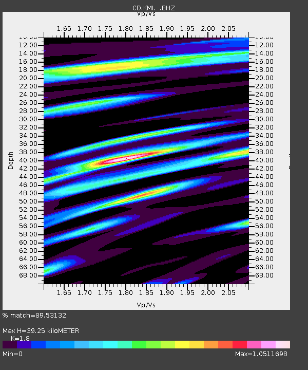
| Estimated Moho Depth: |
39.25 km |
| Estimated Crust Vp/Vs: |
1.80 |
| Assumed Crust Vp: |
6.247 km/s |
| Estimated Crust Vs: |
3.47 km/s |
| Estimated Crust Poisson's Ratio: |
0.28 |
|
| Radial Match: |
89.53132 % |
| Radial Bump: |
400 |
| Transverse Match: |
70.951065 % |
| Transverse Bump: |
400 |
| SOD ConfigId: |
4480 |
| Insert Time: |
2010-02-26 21:21:33.644 +0000 |
| GWidth: |
2.5 |
| Max Bumps: |
400 |
| Tol: |
0.001 |
|
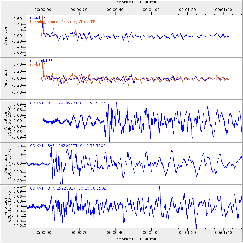
Signal To Noise
| Channel | StoN | STA | LTA |
| CD:KMI: :BHZ:19920927T10:10:58.550Z | 3.3318157 | 5.5547922E-8 | 1.6671967E-8 |
| CD:KMI: :BHN:19920927T10:10:58.550Z | 1.4306622 | 2.0751258E-8 | 1.45046535E-8 |
| CD:KMI: :BHE:19920927T10:10:58.550Z | 1.5789465 | 2.4386676E-8 | 1.5444902E-8 |
| Arrivals |
| Ps | 5.4 SECOND |
| PpPs | 16 SECOND |
| PsPs/PpSs | 22 SECOND |


