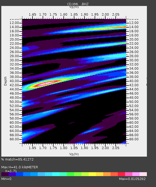
KMI Kunming, Yunnan Province, China - Earthquake Result Viewer
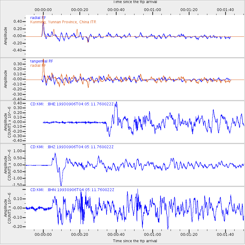
Earthquake location: New Ireland Region, P.N.G.
Earthquake latitude/longitude: -4.7/153.2
Earthquake time(UTC): 1993/09/06 (249) 03:56:02 GMT
Earthquake Depth: 73 km
Earthquake Magnitude: 6.0 MB, 6.6 MS, 6.7 UNKNOWN, 6.6 MW
Earthquake Catalog/Contributor: WHDF/NEIC
Network: CD China Digital Seismograph Network
Station: KMI Kunming, Yunnan Province, China
Lat/Lon: 25.12 N/102.74 E
Elevation: 1975 m
Distance: 57.3 deg
Az: 303.791 deg
Baz: 113.971 deg
Ray Param: 0.06339883
Estimated Moho Depth: 41.0 km
Estimated Crust Vp/Vs: 1.71
Assumed Crust Vp: 6.247 km/s
Estimated Crust Vs: 3.653 km/s
Estimated Crust Poisson's Ratio: 0.24
Radial Match: 85.41272 %
Radial Bump: 400
Transverse Match: 78.98121 %
Transverse Bump: 400
SOD ConfigId: 4480
Insert Time: 2010-02-26 21:21:38.782 +0000
GWidth: 2.5
Max Bumps: 400
Tol: 0.001

Signal To Noise

ChannelStoNSTALTA
CD:KMI: :BHZ:19930906T04:05:11.760022Z5.8009844.6070607E-87.9418605E-9
CD:KMI: :BHN:19930906T04:05:11.760022Z1.10375218.511183E-97.711136E-9
CD:KMI: :BHE:19930906T04:05:11.760022Z2.10926441.4569465E-86.907368E-9
Arrivals
Ps4.9 SECOND
PpPs17 SECOND
PsPs/PpSs22 SECOND