You are here: Home > Network List > GE - GEOFON Stations List
> Station SNAA GEOFON/AWI Station Sanae, Antarctica > Earthquake Result Viewer
SNAA GEOFON/AWI Station Sanae, Antarctica - Earthquake Result Viewer
| Earthquake location: |
West Of Macquarie Island |
| Earthquake latitude/longitude: |
-55.8/146.6 |
| Earthquake time(UTC): |
2011/06/05 (156) 11:51:12 GMT |
| Earthquake Depth: |
3.0 km |
| Earthquake Magnitude: |
5.9 MB, 6.4 MS, 6.4 MW, 6.4 MW |
| Earthquake Catalog/Contributor: |
WHDF/NEIC |
|
| Network: |
GE GEOFON |
| Station: |
SNAA GEOFON/AWI Station Sanae, Antarctica |
| Lat/Lon: |
71.67 S/2.84 W |
| Elevation: |
846 m |
|
| Distance: |
51.0 deg |
| Az: |
191.944 deg |
| Baz: |
158.349 deg |
| Ray Param: |
0.067718774 |
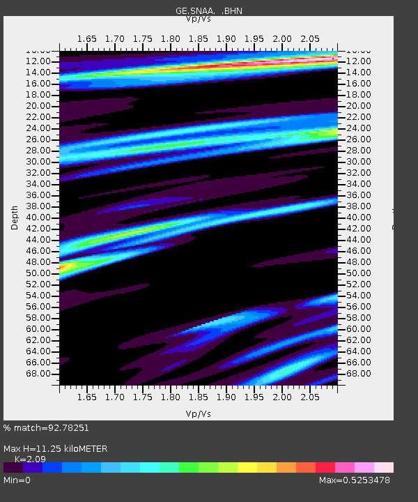
| Estimated Moho Depth: |
11.25 km |
| Estimated Crust Vp/Vs: |
2.09 |
| Assumed Crust Vp: |
6.43 km/s |
| Estimated Crust Vs: |
3.076 km/s |
| Estimated Crust Poisson's Ratio: |
0.35 |
|
| Radial Match: |
92.78251 % |
| Radial Bump: |
233 |
| Transverse Match: |
79.03033 % |
| Transverse Bump: |
400 |
| SOD ConfigId: |
394213 |
| Insert Time: |
2011-11-10 08:43:07.507 +0000 |
| GWidth: |
2.5 |
| Max Bumps: |
400 |
| Tol: |
0.001 |
|

Signal To Noise
| Channel | StoN | STA | LTA |
| GE:SNAA: :BHZ:20110605T11:59:43.911001Z | 11.588421 | 1.389907E-4 | 1.1993929E-5 |
| GE:SNAA: :BHN:20110605T11:59:43.911001Z | 9.97916 | 7.567775E-5 | 7.5835783E-6 |
| GE:SNAA: :BHE:20110605T11:59:43.911001Z | 2.3266618 | 3.300242E-5 | 1.418445E-5 |
| Arrivals |
| Ps | 2.0 SECOND |
| PpPs | 5.2 SECOND |
| PsPs/PpSs | 7.2 SECOND |


