You are here: Home > Network List > CD - China Digital Seismograph Network Stations List
> Station KMI Kunming, Yunnan Province, China > Earthquake Result Viewer
KMI Kunming, Yunnan Province, China - Earthquake Result Viewer

| Earthquake location: |
Kuril Islands |
| Earthquake latitude/longitude: |
43.9/147.4 |
| Earthquake time(UTC): |
1994/10/05 (278) 20:39:47 GMT |
| Earthquake Depth: |
33 km |
| Earthquake Magnitude: |
6.2 MB, 5.6 MS, 5.9 UNKNOWN |
| Earthquake Catalog/Contributor: |
WHDF/NEIC |
|
| Network: |
CD China Digital Seismograph Network |
| Station: |
KMI Kunming, Yunnan Province, China |
| Lat/Lon: |
25.12 N/102.74 E |
| Elevation: |
1975 m |
|
| Distance: |
40.7 deg |
| Az: |
257.566 deg |
| Baz: |
51.168 deg |
| Ray Param: |
0.074187696 |
| Estimated Moho Depth: |
42.75 km |
| Estimated Crust Vp/Vs: |
1.80 |
| Assumed Crust Vp: |
6.247 km/s |
| Estimated Crust Vs: |
3.47 km/s |
| Estimated Crust Poisson's Ratio: |
0.28 |
|
| Radial Match: |
83.909515 % |
| Radial Bump: |
400 |
| Transverse Match: |
79.42207 % |
| Transverse Bump: |
400 |
| SOD ConfigId: |
4480 |
| Insert Time: |
2010-02-26 21:21:43.574 +0000 |
| GWidth: |
2.5 |
| Max Bumps: |
400 |
| Tol: |
0.001 |
|
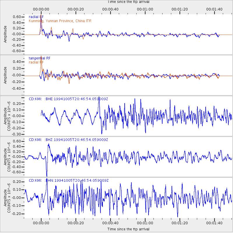
Signal To Noise
| Channel | StoN | STA | LTA |
| CD:KMI: :BHZ:19941005T20:46:54.059009Z | 3.0478039 | 2.9757743E-7 | 9.763667E-8 |
| CD:KMI: :BHN:19941005T20:46:54.059009Z | 1.8685315 | 1.0995057E-7 | 5.8843302E-8 |
| CD:KMI: :BHE:19941005T20:46:54.059009Z | 1.8427559 | 1.2207481E-7 | 6.624578E-8 |
| Arrivals |
| Ps | 5.8 SECOND |
| PpPs | 18 SECOND |
| PsPs/PpSs | 24 SECOND |


