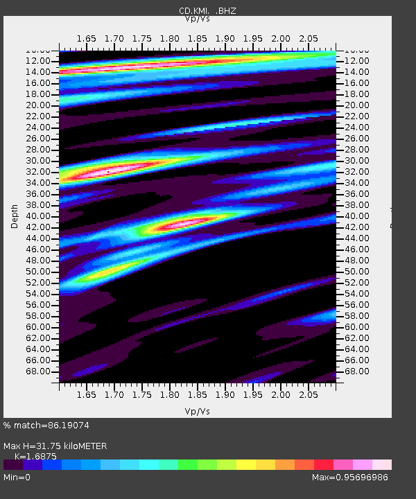
KMI Kunming, Yunnan Province, China - Earthquake Result Viewer

Earthquake location: Fox Islands, Aleutian Islands
Earthquake latitude/longitude: 52.2/-168.7
Earthquake time(UTC): 1996/03/30 (090) 13:05:17 GMT
Earthquake Depth: 33 km
Earthquake Magnitude: 5.9 MB, 6.2 MS, 6.3 UNKNOWN, 6.1 ML
Earthquake Catalog/Contributor: WHDF/NEIC
Network: CD China Digital Seismograph Network
Station: KMI Kunming, Yunnan Province, China
Lat/Lon: 25.12 N/102.74 E
Elevation: 1975 m
Distance: 69.7 deg
Az: 284.917 deg
Baz: 40.986 deg
Ray Param: 0.055432778
Estimated Moho Depth: 31.75 km
Estimated Crust Vp/Vs: 1.69
Assumed Crust Vp: 6.247 km/s
Estimated Crust Vs: 3.702 km/s
Estimated Crust Poisson's Ratio: 0.23
Radial Match: 86.19074 %
Radial Bump: 400
Transverse Match: 84.35543 %
Transverse Bump: 400
SOD ConfigId: 4480
Insert Time: 2010-02-26 21:21:44.790 +0000
GWidth: 2.5
Max Bumps: 400
Tol: 0.001

Signal To Noise

ChannelStoNSTALTA
CD:KMI: :BHZ:19960330T13:15:52.840002Z24.3766963.1086745E-71.2752649E-8
CD:KMI: :BHN:19960330T13:15:52.840002Z9.5711451.08767935E-71.13641505E-8
CD:KMI: :BHE:19960330T13:15:52.840002Z6.94248349.0350895E-81.3014204E-8
Arrivals
Ps3.6 SECOND
PpPs13 SECOND
PsPs/PpSs17 SECOND