You are here: Home > Network List > TA - USArray Transportable Network (new EarthScope stations) Stations List
> Station H17A Grant Village (NPS), Yellowstone Nt. Park, WY, USA > Earthquake Result Viewer
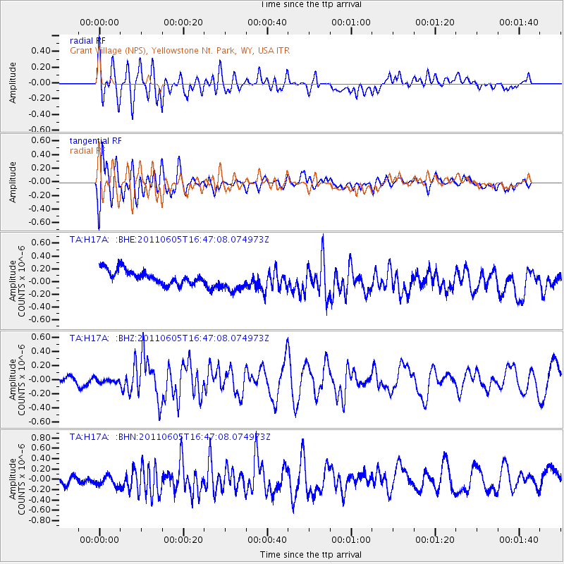
H17A Grant Village (NPS), Yellowstone Nt. Park, WY, USA - Earthquake Result Viewer
*The percent match for this event was below the threshold and hence no stack was calculated.
| Earthquake location: |
Fiji Islands Region |
| Earthquake latitude/longitude: |
-15.1/-177.9 |
| Earthquake time(UTC): |
2011/06/05 (156) 16:35:04 GMT |
| Earthquake Depth: |
13 km |
| Earthquake Magnitude: |
5.5 MB, 5.8 MS, 5.9 MW, 5.8 MW |
| Earthquake Catalog/Contributor: |
WHDF/NEIC |
|
| Network: |
TA USArray Transportable Network (new EarthScope stations) |
| Station: |
H17A Grant Village (NPS), Yellowstone Nt. Park, WY, USA |
| Lat/Lon: |
44.40 N/110.58 W |
| Elevation: |
2400 m |
|
| Distance: |
85.0 deg |
| Az: |
41.596 deg |
| Baz: |
243.436 deg |
| Ray Param: |
$rayparam |
*The percent match for this event was below the threshold and hence was not used in the summary stack. |
|
| Radial Match: |
70.97515 % |
| Radial Bump: |
400 |
| Transverse Match: |
76.91572 % |
| Transverse Bump: |
400 |
| SOD ConfigId: |
394213 |
| Insert Time: |
2011-11-10 08:51:29.190 +0000 |
| GWidth: |
2.5 |
| Max Bumps: |
400 |
| Tol: |
0.001 |
|
Signal To Noise
| Channel | StoN | STA | LTA |
| TA:H17A: :BHZ:20110605T16:47:08.074973Z | 0.56025946 | 2.6554327E-8 | 4.7396483E-8 |
| TA:H17A: :BHN:20110605T16:47:08.074973Z | 1.7714909 | 1.2101918E-7 | 6.8314876E-8 |
| TA:H17A: :BHE:20110605T16:47:08.074973Z | 1.7645172 | 1.8824753E-7 | 1.0668501E-7 |
| Arrivals |
| Ps | |
| PpPs | |
| PsPs/PpSs | |


