You are here: Home > Network List > TA - USArray Transportable Network (new EarthScope stations) Stations List
> Station 333A Richland Springs, TX, USA > Earthquake Result Viewer
333A Richland Springs, TX, USA - Earthquake Result Viewer
| Earthquake location: |
Fiji Islands Region |
| Earthquake latitude/longitude: |
-15.1/-177.9 |
| Earthquake time(UTC): |
2011/06/05 (156) 16:35:04 GMT |
| Earthquake Depth: |
13 km |
| Earthquake Magnitude: |
5.5 MB, 5.8 MS, 5.9 MW, 5.8 MW |
| Earthquake Catalog/Contributor: |
WHDF/NEIC |
|
| Network: |
TA USArray Transportable Network (new EarthScope stations) |
| Station: |
333A Richland Springs, TX, USA |
| Lat/Lon: |
31.32 N/98.98 W |
| Elevation: |
443 m |
|
| Distance: |
88.6 deg |
| Az: |
57.144 deg |
| Baz: |
251.456 deg |
| Ray Param: |
0.042487737 |
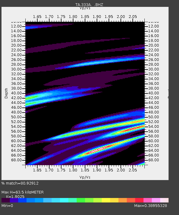
| Estimated Moho Depth: |
63.5 km |
| Estimated Crust Vp/Vs: |
1.90 |
| Assumed Crust Vp: |
6.498 km/s |
| Estimated Crust Vs: |
3.415 km/s |
| Estimated Crust Poisson's Ratio: |
0.31 |
|
| Radial Match: |
80.92912 % |
| Radial Bump: |
400 |
| Transverse Match: |
46.867397 % |
| Transverse Bump: |
400 |
| SOD ConfigId: |
394213 |
| Insert Time: |
2011-11-10 08:53:08.878 +0000 |
| GWidth: |
2.5 |
| Max Bumps: |
400 |
| Tol: |
0.001 |
|

Signal To Noise
| Channel | StoN | STA | LTA |
| TA:333A: :BHZ:20110605T16:47:25.17501Z | 2.6836746 | 1.260787E-7 | 4.6979878E-8 |
| TA:333A: :BHN:20110605T16:47:25.17501Z | 1.1360306 | 5.1168502E-8 | 4.5041485E-8 |
| TA:333A: :BHE:20110605T16:47:25.17501Z | 1.8233566 | 9.7614034E-8 | 5.353535E-8 |
| Arrivals |
| Ps | 9.0 SECOND |
| PpPs | 28 SECOND |
| PsPs/PpSs | 37 SECOND |


