You are here: Home > Network List > TA - USArray Transportable Network (new EarthScope stations) Stations List
> Station D36A Goodland, MN, USA > Earthquake Result Viewer
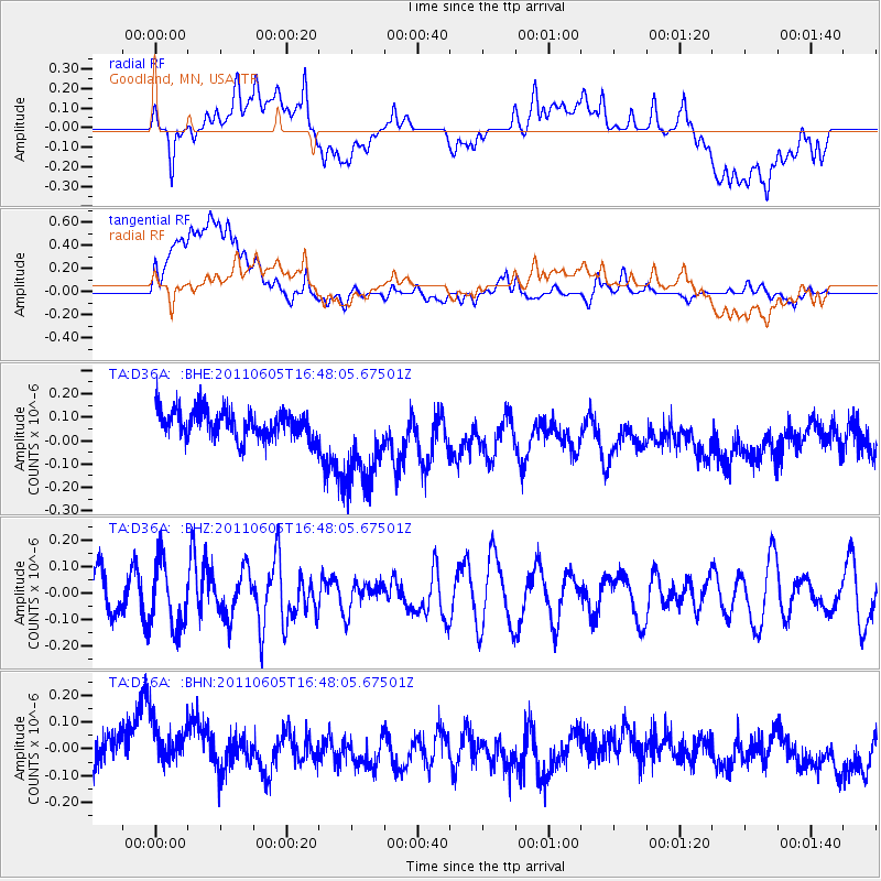
D36A Goodland, MN, USA - Earthquake Result Viewer
*The percent match for this event was below the threshold and hence no stack was calculated.
| Earthquake location: |
Fiji Islands Region |
| Earthquake latitude/longitude: |
-15.1/-177.9 |
| Earthquake time(UTC): |
2011/06/05 (156) 16:35:04 GMT |
| Earthquake Depth: |
13 km |
| Earthquake Magnitude: |
5.5 MB, 5.8 MS, 5.9 MW, 5.8 MW |
| Earthquake Catalog/Contributor: |
WHDF/NEIC |
|
| Network: |
TA USArray Transportable Network (new EarthScope stations) |
| Station: |
D36A Goodland, MN, USA |
| Lat/Lon: |
47.18 N/93.16 W |
| Elevation: |
434 m |
|
| Distance: |
97.4 deg |
| Az: |
43.237 deg |
| Baz: |
255.89 deg |
| Ray Param: |
$rayparam |
*The percent match for this event was below the threshold and hence was not used in the summary stack. |
|
| Radial Match: |
41.65811 % |
| Radial Bump: |
400 |
| Transverse Match: |
50.83088 % |
| Transverse Bump: |
400 |
| SOD ConfigId: |
394213 |
| Insert Time: |
2011-11-10 08:56:03.666 +0000 |
| GWidth: |
2.5 |
| Max Bumps: |
400 |
| Tol: |
0.001 |
|
Signal To Noise
| Channel | StoN | STA | LTA |
| TA:D36A: :BHZ:20110605T16:48:05.67501Z | 1.7382452 | 1.2450423E-7 | 7.162639E-8 |
| TA:D36A: :BHN:20110605T16:48:05.67501Z | 0.9449406 | 1.033034E-7 | 1.0932264E-7 |
| TA:D36A: :BHE:20110605T16:48:05.67501Z | 3.3028154 | 1.97932E-7 | 5.992827E-8 |
| Arrivals |
| Ps | |
| PpPs | |
| PsPs/PpSs | |


