You are here: Home > Network List > CI - Caltech Regional Seismic Network Stations List
> Station GRA Grapevine Ranger Station, Death Valley, CA, USA > Earthquake Result Viewer
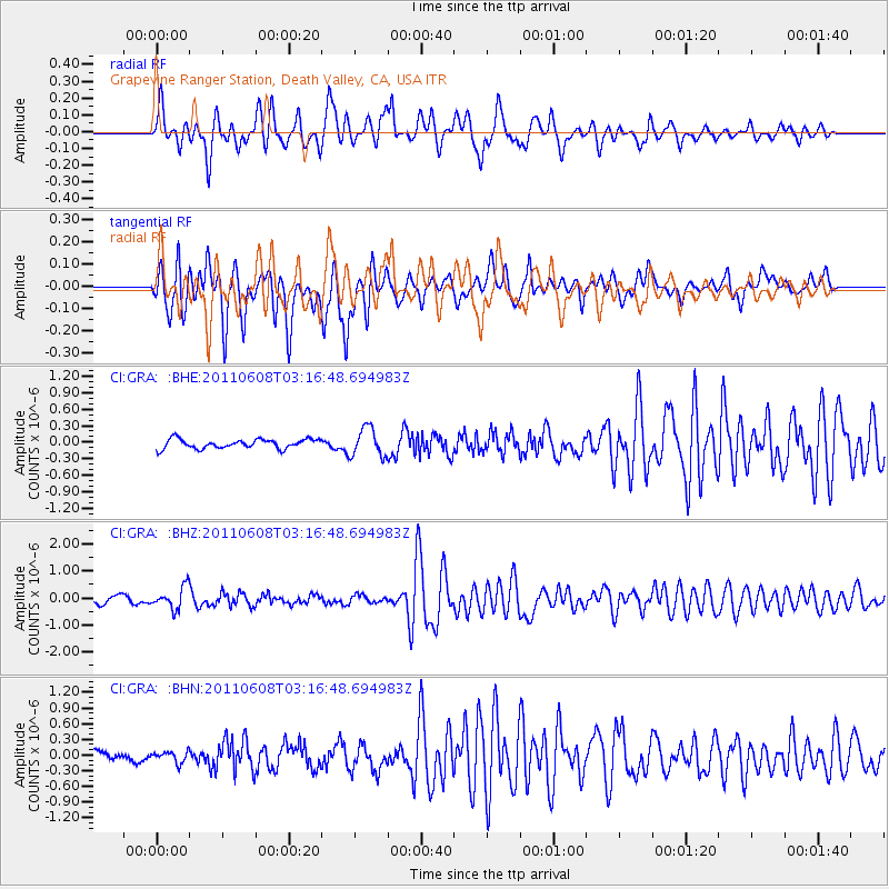
GRA Grapevine Ranger Station, Death Valley, CA, USA - Earthquake Result Viewer
*The percent match for this event was below the threshold and hence no stack was calculated.
| Earthquake location: |
Peru-Bolivia Border Region |
| Earthquake latitude/longitude: |
-17.1/-69.5 |
| Earthquake time(UTC): |
2011/06/08 (159) 03:06:22 GMT |
| Earthquake Depth: |
146 km |
| Earthquake Magnitude: |
5.8 MB, 5.9 MW, 5.9 MW |
| Earthquake Catalog/Contributor: |
WHDF/NEIC |
|
| Network: |
CI Caltech Regional Seismic Network |
| Station: |
GRA Grapevine Ranger Station, Death Valley, CA, USA |
| Lat/Lon: |
37.00 N/117.37 W |
| Elevation: |
689 m |
|
| Distance: |
70.2 deg |
| Az: |
320.884 deg |
| Baz: |
131.09 deg |
| Ray Param: |
$rayparam |
*The percent match for this event was below the threshold and hence was not used in the summary stack. |
|
| Radial Match: |
74.72901 % |
| Radial Bump: |
400 |
| Transverse Match: |
75.131386 % |
| Transverse Bump: |
400 |
| SOD ConfigId: |
394213 |
| Insert Time: |
2011-11-10 09:11:16.128 +0000 |
| GWidth: |
2.5 |
| Max Bumps: |
400 |
| Tol: |
0.001 |
|
Signal To Noise
| Channel | StoN | STA | LTA |
| CI:GRA: :BHZ:20110608T03:16:48.694983Z | 3.826821 | 4.018943E-7 | 1.05020405E-7 |
| CI:GRA: :BHN:20110608T03:16:48.694983Z | 0.9364895 | 1.0648168E-7 | 1.1370301E-7 |
| CI:GRA: :BHE:20110608T03:16:48.694983Z | 3.101652 | 2.60226E-7 | 8.389916E-8 |
| Arrivals |
| Ps | |
| PpPs | |
| PsPs/PpSs | |


