You are here: Home > Network List > XL12 - Hangay Dome, Mongolia Stations List
> Station HD71 HD71 > Earthquake Result Viewer
HD71 HD71 - Earthquake Result Viewer
| Earthquake location: |
Taiwan Region |
| Earthquake latitude/longitude: |
24.1/122.3 |
| Earthquake time(UTC): |
2014/03/19 (078) 12:19:24 GMT |
| Earthquake Depth: |
10 km |
| Earthquake Magnitude: |
5.6 MWB, 5.8 MWW, 5.8 MWC |
| Earthquake Catalog/Contributor: |
NEIC PDE/NEIC COMCAT |
|
| Network: |
XL Hangay Dome, Mongolia |
| Station: |
HD71 HD71 |
| Lat/Lon: |
45.55 N/95.32 E |
| Elevation: |
1915 m |
|
| Distance: |
30.5 deg |
| Az: |
321.197 deg |
| Baz: |
125.413 deg |
| Ray Param: |
0.07930514 |
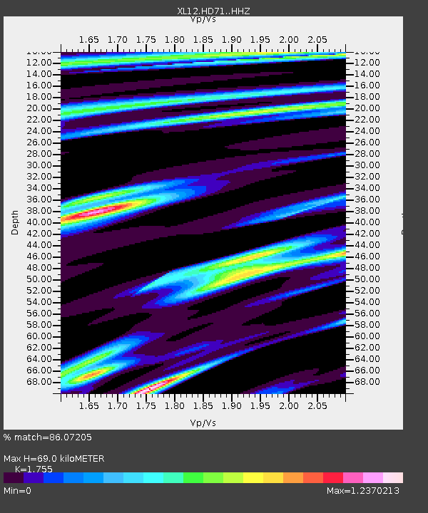
| Estimated Moho Depth: |
69.0 km |
| Estimated Crust Vp/Vs: |
1.75 |
| Assumed Crust Vp: |
6.353 km/s |
| Estimated Crust Vs: |
3.62 km/s |
| Estimated Crust Poisson's Ratio: |
0.26 |
|
| Radial Match: |
86.07205 % |
| Radial Bump: |
301 |
| Transverse Match: |
64.92138 % |
| Transverse Bump: |
400 |
| SOD ConfigId: |
3390531 |
| Insert Time: |
2019-04-10 18:30:40.029 +0000 |
| GWidth: |
2.5 |
| Max Bumps: |
400 |
| Tol: |
0.001 |
|

Signal To Noise
| Channel | StoN | STA | LTA |
| XL:HD71: :HHZ:20140319T12:25:08.299989Z | 5.5762696 | 2.1183585E-7 | 3.7988812E-8 |
| XL:HD71: :HHN:20140319T12:25:08.299989Z | 4.5650816 | 2.4823527E-7 | 5.4376958E-8 |
| XL:HD71: :HHE:20140319T12:25:08.299989Z | 4.8353686 | 2.659403E-7 | 5.4998967E-8 |
| Arrivals |
| Ps | 8.9 SECOND |
| PpPs | 28 SECOND |
| PsPs/PpSs | 37 SECOND |


