You are here: Home > Network List > TA - USArray Transportable Network (new EarthScope stations) Stations List
> Station A27A Ledoux Ranch, Antler, ND, USA > Earthquake Result Viewer
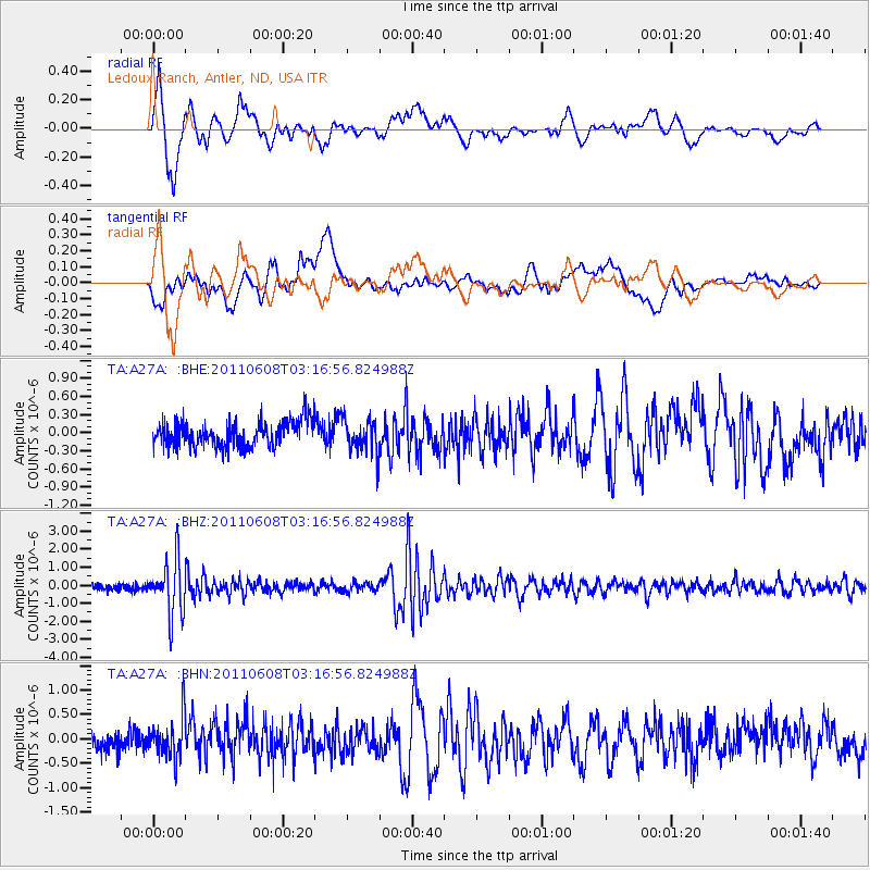
A27A Ledoux Ranch, Antler, ND, USA - Earthquake Result Viewer

| Earthquake location: |
Peru-Bolivia Border Region |
| Earthquake latitude/longitude: |
-17.1/-69.5 |
| Earthquake time(UTC): |
2011/06/08 (159) 03:06:22 GMT |
| Earthquake Depth: |
146 km |
| Earthquake Magnitude: |
5.8 MB, 5.9 MW, 5.9 MW |
| Earthquake Catalog/Contributor: |
WHDF/NEIC |
|
| Network: |
TA USArray Transportable Network (new EarthScope stations) |
| Station: |
A27A Ledoux Ranch, Antler, ND, USA |
| Lat/Lon: |
48.95 N/101.24 W |
| Elevation: |
466 m |
|
| Distance: |
71.5 deg |
| Az: |
338.567 deg |
| Baz: |
147.981 deg |
| Ray Param: |
0.05387848 |
| Estimated Moho Depth: |
28.75 km |
| Estimated Crust Vp/Vs: |
2.07 |
| Assumed Crust Vp: |
6.438 km/s |
| Estimated Crust Vs: |
3.11 km/s |
| Estimated Crust Poisson's Ratio: |
0.35 |
|
| Radial Match: |
84.11083 % |
| Radial Bump: |
400 |
| Transverse Match: |
68.303635 % |
| Transverse Bump: |
400 |
| SOD ConfigId: |
394213 |
| Insert Time: |
2011-11-10 09:21:49.663 +0000 |
| GWidth: |
2.5 |
| Max Bumps: |
400 |
| Tol: |
0.001 |
|
Signal To Noise
| Channel | StoN | STA | LTA |
| TA:A27A: :BHZ:20110608T03:16:56.824988Z | 8.331037 | 1.5179453E-6 | 1.8220366E-7 |
| TA:A27A: :BHN:20110608T03:16:56.824988Z | 1.7139271 | 4.2275192E-7 | 2.4665687E-7 |
| TA:A27A: :BHE:20110608T03:16:56.824988Z | 1.3435699 | 2.85331E-7 | 2.1236782E-7 |
| Arrivals |
| Ps | 4.9 SECOND |
| PpPs | 13 SECOND |
| PsPs/PpSs | 18 SECOND |


