You are here: Home > Network List > TA - USArray Transportable Network (new EarthScope stations) Stations List
> Station F30A Leola, SD, USA > Earthquake Result Viewer
F30A Leola, SD, USA - Earthquake Result Viewer
| Earthquake location: |
Peru-Bolivia Border Region |
| Earthquake latitude/longitude: |
-17.1/-69.5 |
| Earthquake time(UTC): |
2011/06/08 (159) 03:06:22 GMT |
| Earthquake Depth: |
146 km |
| Earthquake Magnitude: |
5.8 MB, 5.9 MW, 5.9 MW |
| Earthquake Catalog/Contributor: |
WHDF/NEIC |
|
| Network: |
TA USArray Transportable Network (new EarthScope stations) |
| Station: |
F30A Leola, SD, USA |
| Lat/Lon: |
45.84 N/99.03 W |
| Elevation: |
601 m |
|
| Distance: |
68.1 deg |
| Az: |
338.213 deg |
| Baz: |
149.486 deg |
| Ray Param: |
0.05613658 |
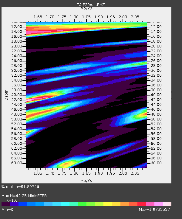
| Estimated Moho Depth: |
42.25 km |
| Estimated Crust Vp/Vs: |
1.60 |
| Assumed Crust Vp: |
6.53 km/s |
| Estimated Crust Vs: |
4.082 km/s |
| Estimated Crust Poisson's Ratio: |
0.18 |
|
| Radial Match: |
91.89746 % |
| Radial Bump: |
327 |
| Transverse Match: |
83.33936 % |
| Transverse Bump: |
400 |
| SOD ConfigId: |
394213 |
| Insert Time: |
2011-11-10 09:22:52.717 +0000 |
| GWidth: |
2.5 |
| Max Bumps: |
400 |
| Tol: |
0.001 |
|

Signal To Noise
| Channel | StoN | STA | LTA |
| TA:F30A: :BHZ:20110608T03:16:35.800024Z | 7.264379 | 1.3655659E-6 | 1.8798109E-7 |
| TA:F30A: :BHN:20110608T03:16:35.800024Z | 2.6201842 | 7.004554E-7 | 2.673306E-7 |
| TA:F30A: :BHE:20110608T03:16:35.800024Z | 2.9776945 | 4.9463233E-7 | 1.6611253E-7 |
| Arrivals |
| Ps | 4.1 SECOND |
| PpPs | 16 SECOND |
| PsPs/PpSs | 20 SECOND |


