You are here: Home > Network List > TA - USArray Transportable Network (new EarthScope stations) Stations List
> Station Z35A Perchaven, Sanger, TX, USA > Earthquake Result Viewer
Z35A Perchaven, Sanger, TX, USA - Earthquake Result Viewer
| Earthquake location: |
Peru-Bolivia Border Region |
| Earthquake latitude/longitude: |
-17.1/-69.5 |
| Earthquake time(UTC): |
2011/06/08 (159) 03:06:22 GMT |
| Earthquake Depth: |
146 km |
| Earthquake Magnitude: |
5.8 MB, 5.9 MW, 5.9 MW |
| Earthquake Catalog/Contributor: |
WHDF/NEIC |
|
| Network: |
TA USArray Transportable Network (new EarthScope stations) |
| Station: |
Z35A Perchaven, Sanger, TX, USA |
| Lat/Lon: |
33.33 N/97.25 W |
| Elevation: |
235 m |
|
| Distance: |
56.7 deg |
| Az: |
332.214 deg |
| Baz: |
147.821 deg |
| Ray Param: |
0.063509665 |
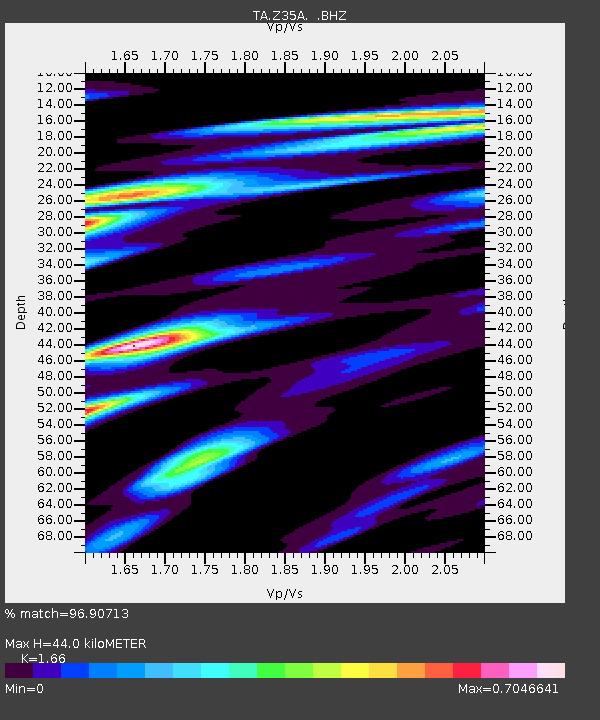
| Estimated Moho Depth: |
44.0 km |
| Estimated Crust Vp/Vs: |
1.66 |
| Assumed Crust Vp: |
6.38 km/s |
| Estimated Crust Vs: |
3.844 km/s |
| Estimated Crust Poisson's Ratio: |
0.22 |
|
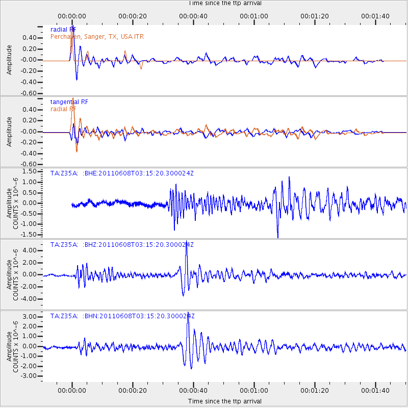
| Radial Match: |
96.90713 % |
| Radial Bump: |
371 |
| Transverse Match: |
86.39848 % |
| Transverse Bump: |
400 |
| SOD ConfigId: |
394213 |
| Insert Time: |
2011-11-10 09:26:56.839 +0000 |
| GWidth: |
2.5 |
| Max Bumps: |
400 |
| Tol: |
0.001 |
|
Signal To Noise
| Channel | StoN | STA | LTA |
| TA:Z35A: :BHZ:20110608T03:15:20.300024Z | 11.2465315 | 9.5135044E-7 | 8.459056E-8 |
| TA:Z35A: :BHN:20110608T03:15:20.300024Z | 4.7291226 | 3.4614257E-7 | 7.3193824E-8 |
| TA:Z35A: :BHE:20110608T03:15:20.300024Z | 5.2094784 | 4.2628045E-7 | 8.182786E-8 |
| Arrivals |
| Ps | 4.8 SECOND |
| PpPs | 17 SECOND |
| PsPs/PpSs | 22 SECOND |


