You are here: Home > Network List > TA - USArray Transportable Network (new EarthScope stations) Stations List
> Station 133A Hamilton Ranch, Breckenridge, TX, USA > Earthquake Result Viewer
133A Hamilton Ranch, Breckenridge, TX, USA - Earthquake Result Viewer
| Earthquake location: |
Peru-Bolivia Border Region |
| Earthquake latitude/longitude: |
-17.1/-69.5 |
| Earthquake time(UTC): |
2011/06/08 (159) 03:06:22 GMT |
| Earthquake Depth: |
146 km |
| Earthquake Magnitude: |
5.8 MB, 5.9 MW, 5.9 MW |
| Earthquake Catalog/Contributor: |
WHDF/NEIC |
|
| Network: |
TA USArray Transportable Network (new EarthScope stations) |
| Station: |
133A Hamilton Ranch, Breckenridge, TX, USA |
| Lat/Lon: |
32.61 N/98.92 W |
| Elevation: |
418 m |
|
| Distance: |
56.9 deg |
| Az: |
330.344 deg |
| Baz: |
145.896 deg |
| Ray Param: |
0.063408 |
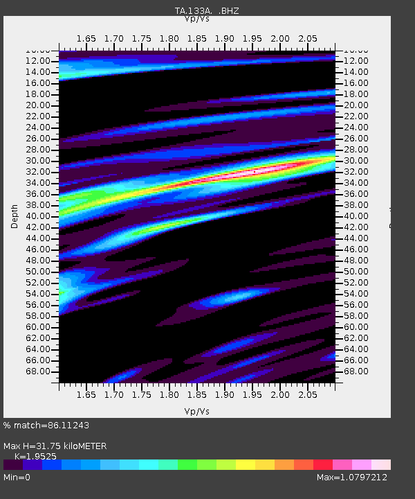
| Estimated Moho Depth: |
31.75 km |
| Estimated Crust Vp/Vs: |
1.95 |
| Assumed Crust Vp: |
6.426 km/s |
| Estimated Crust Vs: |
3.291 km/s |
| Estimated Crust Poisson's Ratio: |
0.32 |
|
| Radial Match: |
86.11243 % |
| Radial Bump: |
400 |
| Transverse Match: |
78.66441 % |
| Transverse Bump: |
400 |
| SOD ConfigId: |
394213 |
| Insert Time: |
2011-11-10 09:27:06.642 +0000 |
| GWidth: |
2.5 |
| Max Bumps: |
400 |
| Tol: |
0.001 |
|
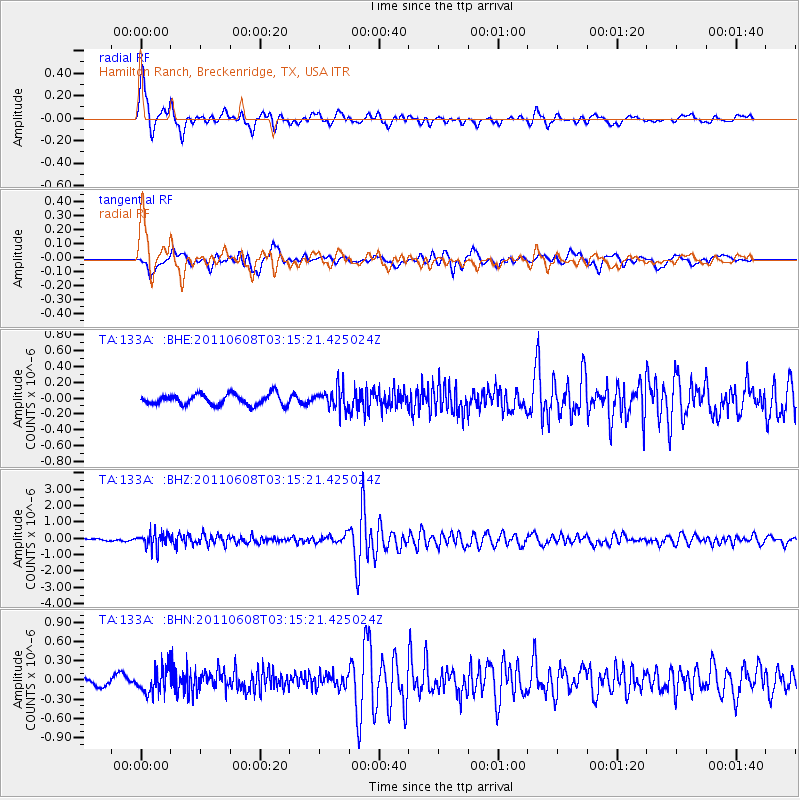
Signal To Noise
| Channel | StoN | STA | LTA |
| TA:133A: :BHZ:20110608T03:15:21.425024Z | 7.169164 | 4.824842E-7 | 6.729992E-8 |
| TA:133A: :BHN:20110608T03:15:21.425024Z | 3.32719 | 2.0082464E-7 | 6.035864E-8 |
| TA:133A: :BHE:20110608T03:15:21.425024Z | 2.0052187 | 1.3577313E-7 | 6.770989E-8 |
| Arrivals |
| Ps | 4.9 SECOND |
| PpPs | 14 SECOND |
| PsPs/PpSs | 19 SECOND |


