You are here: Home > Network List > TA - USArray Transportable Network (new EarthScope stations) Stations List
> Station 234A Clairette, TX, USA > Earthquake Result Viewer
234A Clairette, TX, USA - Earthquake Result Viewer
| Earthquake location: |
Peru-Bolivia Border Region |
| Earthquake latitude/longitude: |
-17.1/-69.5 |
| Earthquake time(UTC): |
2011/06/08 (159) 03:06:22 GMT |
| Earthquake Depth: |
146 km |
| Earthquake Magnitude: |
5.8 MB, 5.9 MW, 5.9 MW |
| Earthquake Catalog/Contributor: |
WHDF/NEIC |
|
| Network: |
TA USArray Transportable Network (new EarthScope stations) |
| Station: |
234A Clairette, TX, USA |
| Lat/Lon: |
32.00 N/98.14 W |
| Elevation: |
358 m |
|
| Distance: |
56.0 deg |
| Az: |
330.599 deg |
| Baz: |
146.452 deg |
| Ray Param: |
0.06396511 |
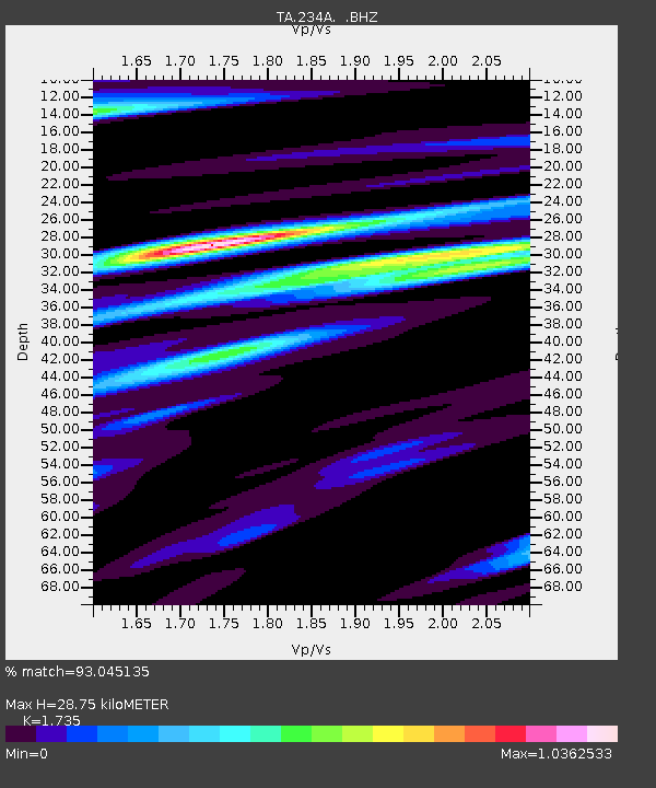
| Estimated Moho Depth: |
28.75 km |
| Estimated Crust Vp/Vs: |
1.74 |
| Assumed Crust Vp: |
6.426 km/s |
| Estimated Crust Vs: |
3.704 km/s |
| Estimated Crust Poisson's Ratio: |
0.25 |
|
| Radial Match: |
93.045135 % |
| Radial Bump: |
400 |
| Transverse Match: |
79.37463 % |
| Transverse Bump: |
400 |
| SOD ConfigId: |
394213 |
| Insert Time: |
2011-11-10 09:27:45.869 +0000 |
| GWidth: |
2.5 |
| Max Bumps: |
400 |
| Tol: |
0.001 |
|
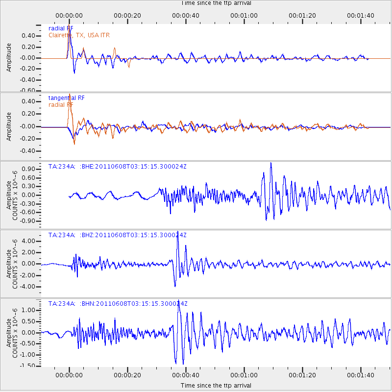
Signal To Noise
| Channel | StoN | STA | LTA |
| TA:234A: :BHZ:20110608T03:15:15.300024Z | 6.3936915 | 7.259698E-7 | 1.135447E-7 |
| TA:234A: :BHN:20110608T03:15:15.300024Z | 3.4356563 | 2.6237032E-7 | 7.636687E-8 |
| TA:234A: :BHE:20110608T03:15:15.300024Z | 2.4398026 | 1.8515478E-7 | 7.588924E-8 |
| Arrivals |
| Ps | 3.5 SECOND |
| PpPs | 12 SECOND |
| PsPs/PpSs | 15 SECOND |


