You are here: Home > Network List > TA - USArray Transportable Network (new EarthScope stations) Stations List
> Station V35A Meyer Ranch, Chandler, OK, USA > Earthquake Result Viewer
V35A Meyer Ranch, Chandler, OK, USA - Earthquake Result Viewer
| Earthquake location: |
Peru-Bolivia Border Region |
| Earthquake latitude/longitude: |
-17.1/-69.5 |
| Earthquake time(UTC): |
2011/06/08 (159) 03:06:22 GMT |
| Earthquake Depth: |
146 km |
| Earthquake Magnitude: |
5.8 MB, 5.9 MW, 5.9 MW |
| Earthquake Catalog/Contributor: |
WHDF/NEIC |
|
| Network: |
TA USArray Transportable Network (new EarthScope stations) |
| Station: |
V35A Meyer Ranch, Chandler, OK, USA |
| Lat/Lon: |
35.76 N/96.84 W |
| Elevation: |
280 m |
|
| Distance: |
58.6 deg |
| Az: |
334.063 deg |
| Baz: |
149.046 deg |
| Ray Param: |
0.062294386 |
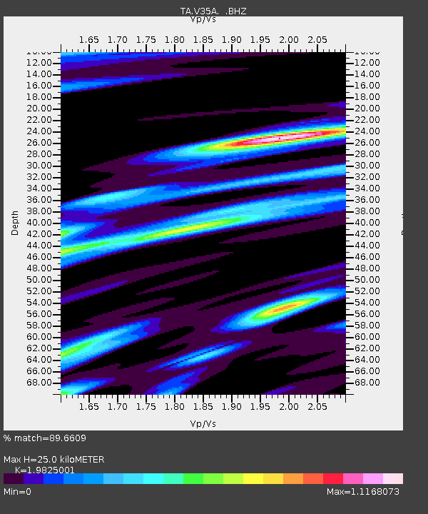
| Estimated Moho Depth: |
25.0 km |
| Estimated Crust Vp/Vs: |
1.98 |
| Assumed Crust Vp: |
6.426 km/s |
| Estimated Crust Vs: |
3.241 km/s |
| Estimated Crust Poisson's Ratio: |
0.33 |
|
| Radial Match: |
89.6609 % |
| Radial Bump: |
400 |
| Transverse Match: |
80.15902 % |
| Transverse Bump: |
400 |
| SOD ConfigId: |
394213 |
| Insert Time: |
2011-11-10 09:30:50.335 +0000 |
| GWidth: |
2.5 |
| Max Bumps: |
400 |
| Tol: |
0.001 |
|
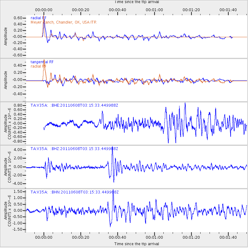
Signal To Noise
| Channel | StoN | STA | LTA |
| TA:V35A: :BHZ:20110608T03:15:33.449988Z | 17.034727 | 1.0404154E-6 | 6.107614E-8 |
| TA:V35A: :BHN:20110608T03:15:33.449988Z | 2.9411356 | 2.6590627E-7 | 9.040939E-8 |
| TA:V35A: :BHE:20110608T03:15:33.449988Z | 2.3963697 | 2.0930656E-7 | 8.734319E-8 |
| Arrivals |
| Ps | 4.0 SECOND |
| PpPs | 11 SECOND |
| PsPs/PpSs | 15 SECOND |


