You are here: Home > Network List > TA - USArray Transportable Network (new EarthScope stations) Stations List
> Station W36A Wetumka, OK, USA > Earthquake Result Viewer
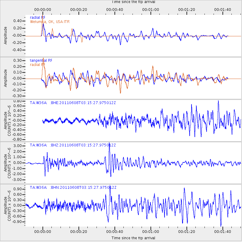
W36A Wetumka, OK, USA - Earthquake Result Viewer
*The percent match for this event was below the threshold and hence no stack was calculated.
| Earthquake location: |
Peru-Bolivia Border Region |
| Earthquake latitude/longitude: |
-17.1/-69.5 |
| Earthquake time(UTC): |
2011/06/08 (159) 03:06:22 GMT |
| Earthquake Depth: |
146 km |
| Earthquake Magnitude: |
5.8 MB, 5.9 MW, 5.9 MW |
| Earthquake Catalog/Contributor: |
WHDF/NEIC |
|
| Network: |
TA USArray Transportable Network (new EarthScope stations) |
| Station: |
W36A Wetumka, OK, USA |
| Lat/Lon: |
35.14 N/96.23 W |
| Elevation: |
251 m |
|
| Distance: |
57.8 deg |
| Az: |
334.194 deg |
| Baz: |
149.468 deg |
| Ray Param: |
$rayparam |
*The percent match for this event was below the threshold and hence was not used in the summary stack. |
|
| Radial Match: |
79.65822 % |
| Radial Bump: |
400 |
| Transverse Match: |
78.430824 % |
| Transverse Bump: |
400 |
| SOD ConfigId: |
394213 |
| Insert Time: |
2011-11-10 09:31:29.818 +0000 |
| GWidth: |
2.5 |
| Max Bumps: |
400 |
| Tol: |
0.001 |
|
Signal To Noise
| Channel | StoN | STA | LTA |
| TA:W36A: :BHZ:20110608T03:15:27.975012Z | 12.744007 | 8.301742E-7 | 6.5142316E-8 |
| TA:W36A: :BHN:20110608T03:15:27.975012Z | 2.3843923 | 1.8269881E-7 | 7.66228E-8 |
| TA:W36A: :BHE:20110608T03:15:27.975012Z | 1.7157705 | 1.0537543E-7 | 6.1415804E-8 |
| Arrivals |
| Ps | |
| PpPs | |
| PsPs/PpSs | |


