You are here: Home > Network List > TA - USArray Transportable Network (new EarthScope stations) Stations List
> Station Z38A Mt. Pleasant, TX, USA > Earthquake Result Viewer
Z38A Mt. Pleasant, TX, USA - Earthquake Result Viewer
| Earthquake location: |
Peru-Bolivia Border Region |
| Earthquake latitude/longitude: |
-17.1/-69.5 |
| Earthquake time(UTC): |
2011/06/08 (159) 03:06:22 GMT |
| Earthquake Depth: |
146 km |
| Earthquake Magnitude: |
5.8 MB, 5.9 MW, 5.9 MW |
| Earthquake Catalog/Contributor: |
WHDF/NEIC |
|
| Network: |
TA USArray Transportable Network (new EarthScope stations) |
| Station: |
Z38A Mt. Pleasant, TX, USA |
| Lat/Lon: |
33.25 N/94.99 W |
| Elevation: |
116 m |
|
| Distance: |
55.6 deg |
| Az: |
334.123 deg |
| Baz: |
150.123 deg |
| Ray Param: |
0.06418618 |
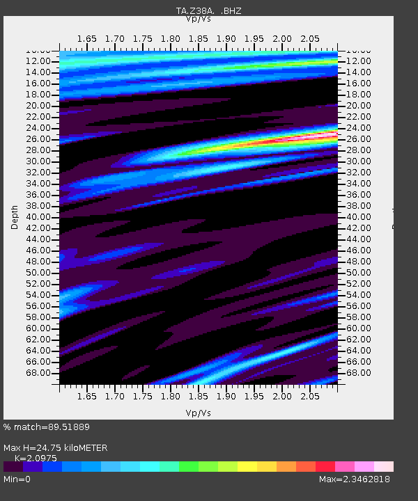
| Estimated Moho Depth: |
24.75 km |
| Estimated Crust Vp/Vs: |
2.10 |
| Assumed Crust Vp: |
6.245 km/s |
| Estimated Crust Vs: |
2.977 km/s |
| Estimated Crust Poisson's Ratio: |
0.35 |
|
| Radial Match: |
89.51889 % |
| Radial Bump: |
400 |
| Transverse Match: |
80.729454 % |
| Transverse Bump: |
400 |
| SOD ConfigId: |
394213 |
| Insert Time: |
2011-11-10 09:32:17.016 +0000 |
| GWidth: |
2.5 |
| Max Bumps: |
400 |
| Tol: |
0.001 |
|

Signal To Noise
| Channel | StoN | STA | LTA |
| TA:Z38A: :BHZ:20110608T03:15:12.874976Z | 8.40616 | 8.401882E-7 | 9.99491E-8 |
| TA:Z38A: :BHN:20110608T03:15:12.874976Z | 1.1959747 | 1.7421736E-7 | 1.4566977E-7 |
| TA:Z38A: :BHE:20110608T03:15:12.874976Z | 1.9352111 | 2.3542572E-7 | 1.2165377E-7 |
| Arrivals |
| Ps | 4.5 SECOND |
| PpPs | 12 SECOND |
| PsPs/PpSs | 16 SECOND |


