You are here: Home > Network List > TA - USArray Transportable Network (new EarthScope stations) Stations List
> Station Y35A Marietta, OK, USA > Earthquake Result Viewer
Y35A Marietta, OK, USA - Earthquake Result Viewer
| Earthquake location: |
Peru-Bolivia Border Region |
| Earthquake latitude/longitude: |
-17.1/-69.5 |
| Earthquake time(UTC): |
2011/06/08 (159) 03:06:22 GMT |
| Earthquake Depth: |
146 km |
| Earthquake Magnitude: |
5.8 MB, 5.9 MW, 5.9 MW |
| Earthquake Catalog/Contributor: |
WHDF/NEIC |
|
| Network: |
TA USArray Transportable Network (new EarthScope stations) |
| Station: |
Y35A Marietta, OK, USA |
| Lat/Lon: |
33.91 N/97.04 W |
| Elevation: |
214 m |
|
| Distance: |
57.1 deg |
| Az: |
332.759 deg |
| Baz: |
148.238 deg |
| Ray Param: |
0.06326275 |
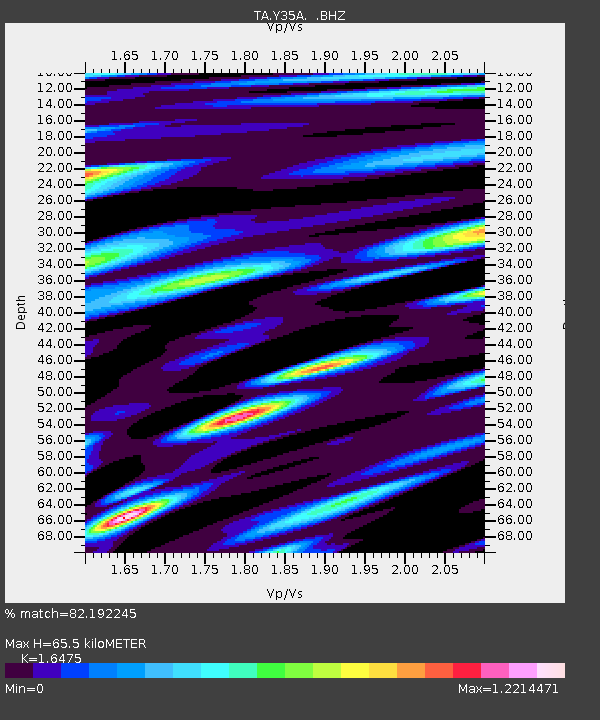
| Estimated Moho Depth: |
65.5 km |
| Estimated Crust Vp/Vs: |
1.65 |
| Assumed Crust Vp: |
6.38 km/s |
| Estimated Crust Vs: |
3.873 km/s |
| Estimated Crust Poisson's Ratio: |
0.21 |
|
| Radial Match: |
82.192245 % |
| Radial Bump: |
400 |
| Transverse Match: |
82.33878 % |
| Transverse Bump: |
400 |
| SOD ConfigId: |
394213 |
| Insert Time: |
2011-11-10 09:32:22.229 +0000 |
| GWidth: |
2.5 |
| Max Bumps: |
400 |
| Tol: |
0.001 |
|
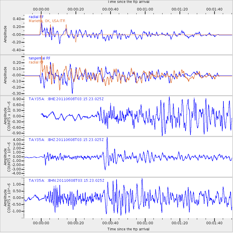
Signal To Noise
| Channel | StoN | STA | LTA |
| TA:Y35A: :BHZ:20110608T03:15:23.025Z | 5.0236077 | 5.585519E-7 | 1.1118541E-7 |
| TA:Y35A: :BHN:20110608T03:15:23.025Z | 1.4213458 | 1.4935124E-7 | 1.0507734E-7 |
| TA:Y35A: :BHE:20110608T03:15:23.025Z | 1.4660493 | 1.5561604E-7 | 1.0614652E-7 |
| Arrivals |
| Ps | 7.0 SECOND |
| PpPs | 26 SECOND |
| PsPs/PpSs | 33 SECOND |


