You are here: Home > Network List > TA - USArray Transportable Network (new EarthScope stations) Stations List
> Station R34A Isabella, Hillsboro, KS, USA > Earthquake Result Viewer
R34A Isabella, Hillsboro, KS, USA - Earthquake Result Viewer

| Earthquake location: |
Peru-Bolivia Border Region |
| Earthquake latitude/longitude: |
-17.1/-69.5 |
| Earthquake time(UTC): |
2011/06/08 (159) 03:06:22 GMT |
| Earthquake Depth: |
146 km |
| Earthquake Magnitude: |
5.8 MB, 5.9 MW, 5.9 MW |
| Earthquake Catalog/Contributor: |
WHDF/NEIC |
|
| Network: |
TA USArray Transportable Network (new EarthScope stations) |
| Station: |
R34A Isabella, Hillsboro, KS, USA |
| Lat/Lon: |
38.30 N/97.25 W |
| Elevation: |
437 m |
|
| Distance: |
60.9 deg |
| Az: |
335.238 deg |
| Baz: |
149.392 deg |
| Ray Param: |
0.060770508 |
| Estimated Moho Depth: |
54.5 km |
| Estimated Crust Vp/Vs: |
1.62 |
| Assumed Crust Vp: |
6.483 km/s |
| Estimated Crust Vs: |
4.002 km/s |
| Estimated Crust Poisson's Ratio: |
0.19 |
|
| Radial Match: |
89.39826 % |
| Radial Bump: |
400 |
| Transverse Match: |
54.48761 % |
| Transverse Bump: |
400 |
| SOD ConfigId: |
394213 |
| Insert Time: |
2011-11-10 09:33:51.885 +0000 |
| GWidth: |
2.5 |
| Max Bumps: |
400 |
| Tol: |
0.001 |
|
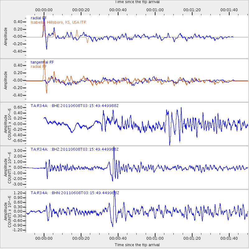
Signal To Noise
| Channel | StoN | STA | LTA |
| TA:R34A: :BHZ:20110608T03:15:49.449988Z | 8.125771 | 7.0598946E-7 | 8.688277E-8 |
| TA:R34A: :BHN:20110608T03:15:49.449988Z | 3.5192792 | 2.717761E-7 | 7.7224925E-8 |
| TA:R34A: :BHE:20110608T03:15:49.449988Z | 1.755809 | 2.0144383E-7 | 1.1472993E-7 |
| Arrivals |
| Ps | 5.5 SECOND |
| PpPs | 21 SECOND |
| PsPs/PpSs | 26 SECOND |


