You are here: Home > Network List > TA - USArray Transportable Network (new EarthScope stations) Stations List
> Station K31A O'Neill, NE, USA > Earthquake Result Viewer
K31A O'Neill, NE, USA - Earthquake Result Viewer
| Earthquake location: |
Peru-Bolivia Border Region |
| Earthquake latitude/longitude: |
-17.1/-69.5 |
| Earthquake time(UTC): |
2011/06/08 (159) 03:06:22 GMT |
| Earthquake Depth: |
146 km |
| Earthquake Magnitude: |
5.8 MB, 5.9 MW, 5.9 MW |
| Earthquake Catalog/Contributor: |
WHDF/NEIC |
|
| Network: |
TA USArray Transportable Network (new EarthScope stations) |
| Station: |
K31A O'Neill, NE, USA |
| Lat/Lon: |
42.62 N/98.75 W |
| Elevation: |
580 m |
|
| Distance: |
65.2 deg |
| Az: |
336.607 deg |
| Baz: |
149.037 deg |
| Ray Param: |
0.057995595 |
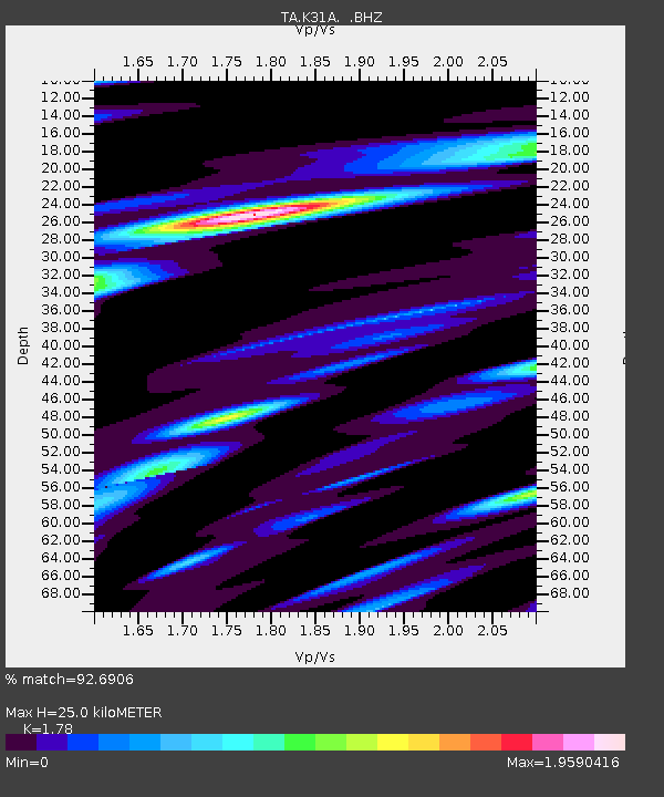
| Estimated Moho Depth: |
25.0 km |
| Estimated Crust Vp/Vs: |
1.78 |
| Assumed Crust Vp: |
6.53 km/s |
| Estimated Crust Vs: |
3.669 km/s |
| Estimated Crust Poisson's Ratio: |
0.27 |
|
| Radial Match: |
92.6906 % |
| Radial Bump: |
400 |
| Transverse Match: |
92.17231 % |
| Transverse Bump: |
400 |
| SOD ConfigId: |
394213 |
| Insert Time: |
2011-11-10 09:38:50.297 +0000 |
| GWidth: |
2.5 |
| Max Bumps: |
400 |
| Tol: |
0.001 |
|
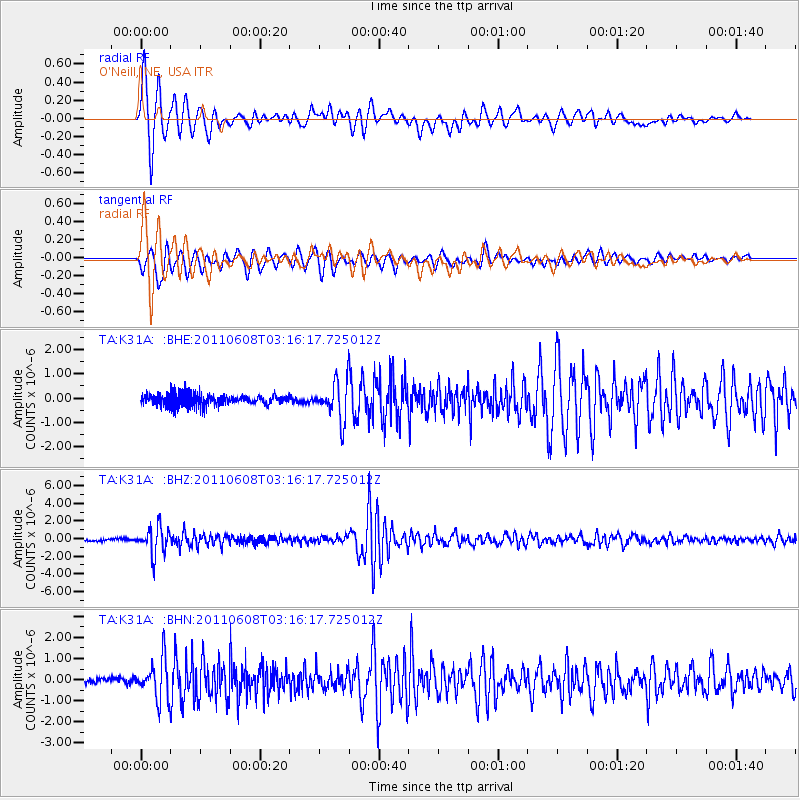
Signal To Noise
| Channel | StoN | STA | LTA |
| TA:K31A: :BHZ:20110608T03:16:17.725012Z | 6.581079 | 1.52917E-6 | 2.3235856E-7 |
| TA:K31A: :BHN:20110608T03:16:17.725012Z | 4.449042 | 9.3019037E-7 | 2.0907656E-7 |
| TA:K31A: :BHE:20110608T03:16:17.725012Z | 3.423847 | 7.774298E-7 | 2.2706324E-7 |
| Arrivals |
| Ps | 3.1 SECOND |
| PpPs | 10 SECOND |
| PsPs/PpSs | 13 SECOND |


