You are here: Home > Network List > TA - USArray Transportable Network (new EarthScope stations) Stations List
> Station F36A Milaca, MN, USA > Earthquake Result Viewer
F36A Milaca, MN, USA - Earthquake Result Viewer
| Earthquake location: |
Peru-Bolivia Border Region |
| Earthquake latitude/longitude: |
-17.1/-69.5 |
| Earthquake time(UTC): |
2011/06/08 (159) 03:06:22 GMT |
| Earthquake Depth: |
146 km |
| Earthquake Magnitude: |
5.8 MB, 5.9 MW, 5.9 MW |
| Earthquake Catalog/Contributor: |
WHDF/NEIC |
|
| Network: |
TA USArray Transportable Network (new EarthScope stations) |
| Station: |
F36A Milaca, MN, USA |
| Lat/Lon: |
45.86 N/93.52 W |
| Elevation: |
345 m |
|
| Distance: |
66.3 deg |
| Az: |
341.914 deg |
| Baz: |
154.856 deg |
| Ray Param: |
0.05728441 |
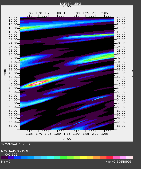
| Estimated Moho Depth: |
45.0 km |
| Estimated Crust Vp/Vs: |
1.70 |
| Assumed Crust Vp: |
6.571 km/s |
| Estimated Crust Vs: |
3.876 km/s |
| Estimated Crust Poisson's Ratio: |
0.23 |
|
| Radial Match: |
87.17384 % |
| Radial Bump: |
400 |
| Transverse Match: |
72.438385 % |
| Transverse Bump: |
400 |
| SOD ConfigId: |
394213 |
| Insert Time: |
2011-11-10 09:40:42.553 +0000 |
| GWidth: |
2.5 |
| Max Bumps: |
400 |
| Tol: |
0.001 |
|
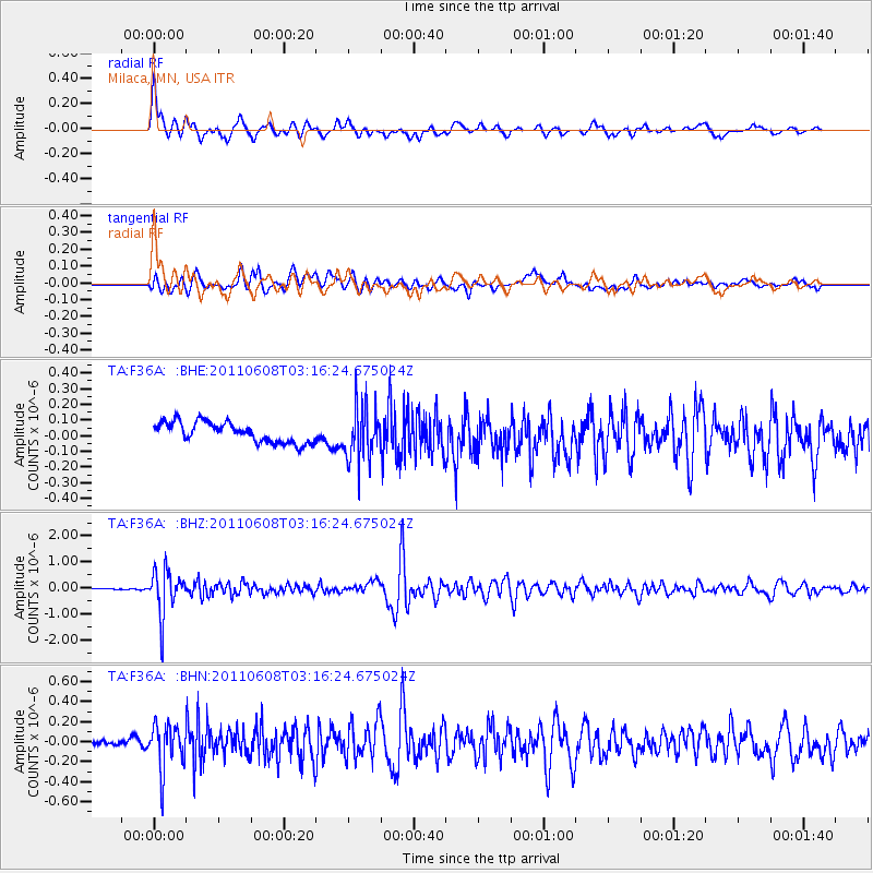
Signal To Noise
| Channel | StoN | STA | LTA |
| TA:F36A: :BHZ:20110608T03:16:24.675024Z | 19.77564 | 8.7009846E-7 | 4.3998497E-8 |
| TA:F36A: :BHN:20110608T03:16:24.675024Z | 5.235256 | 2.2682585E-7 | 4.3326597E-8 |
| TA:F36A: :BHE:20110608T03:16:24.675024Z | 2.6691377 | 1.7058667E-7 | 6.3910775E-8 |
| Arrivals |
| Ps | 5.0 SECOND |
| PpPs | 18 SECOND |
| PsPs/PpSs | 23 SECOND |


