You are here: Home > Network List > TA - USArray Transportable Network (new EarthScope stations) Stations List
> Station N37A Lee Faris, Mount Ayr, IA, USA > Earthquake Result Viewer
N37A Lee Faris, Mount Ayr, IA, USA - Earthquake Result Viewer
| Earthquake location: |
Peru-Bolivia Border Region |
| Earthquake latitude/longitude: |
-17.1/-69.5 |
| Earthquake time(UTC): |
2011/06/08 (159) 03:06:22 GMT |
| Earthquake Depth: |
146 km |
| Earthquake Magnitude: |
5.8 MB, 5.9 MW, 5.9 MW |
| Earthquake Catalog/Contributor: |
WHDF/NEIC |
|
| Network: |
TA USArray Transportable Network (new EarthScope stations) |
| Station: |
N37A Lee Faris, Mount Ayr, IA, USA |
| Lat/Lon: |
40.76 N/94.21 W |
| Elevation: |
351 m |
|
| Distance: |
62.0 deg |
| Az: |
338.927 deg |
| Baz: |
153.083 deg |
| Ray Param: |
0.06011232 |
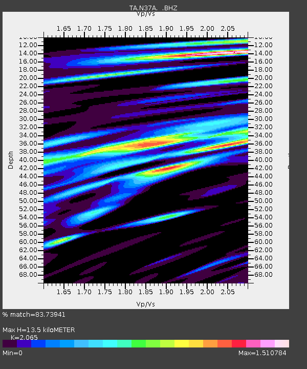
| Estimated Moho Depth: |
13.5 km |
| Estimated Crust Vp/Vs: |
2.07 |
| Assumed Crust Vp: |
6.498 km/s |
| Estimated Crust Vs: |
3.147 km/s |
| Estimated Crust Poisson's Ratio: |
0.35 |
|
| Radial Match: |
83.73941 % |
| Radial Bump: |
400 |
| Transverse Match: |
53.191555 % |
| Transverse Bump: |
400 |
| SOD ConfigId: |
394213 |
| Insert Time: |
2011-11-10 09:43:32.015 +0000 |
| GWidth: |
2.5 |
| Max Bumps: |
400 |
| Tol: |
0.001 |
|

Signal To Noise
| Channel | StoN | STA | LTA |
| TA:N37A: :BHZ:20110608T03:15:56.275Z | 9.366138 | 9.184464E-7 | 9.8060305E-8 |
| TA:N37A: :BHN:20110608T03:15:56.275Z | 9.599991 | 7.209745E-7 | 7.510159E-8 |
| TA:N37A: :BHE:20110608T03:15:56.275Z | 2.9156053 | 4.3533177E-7 | 1.4931094E-7 |
| Arrivals |
| Ps | 2.3 SECOND |
| PpPs | 6.1 SECOND |
| PsPs/PpSs | 8.4 SECOND |


