You are here: Home > Network List > TA - USArray Transportable Network (new EarthScope stations) Stations List
> Station O38A Galt, MO, USA > Earthquake Result Viewer
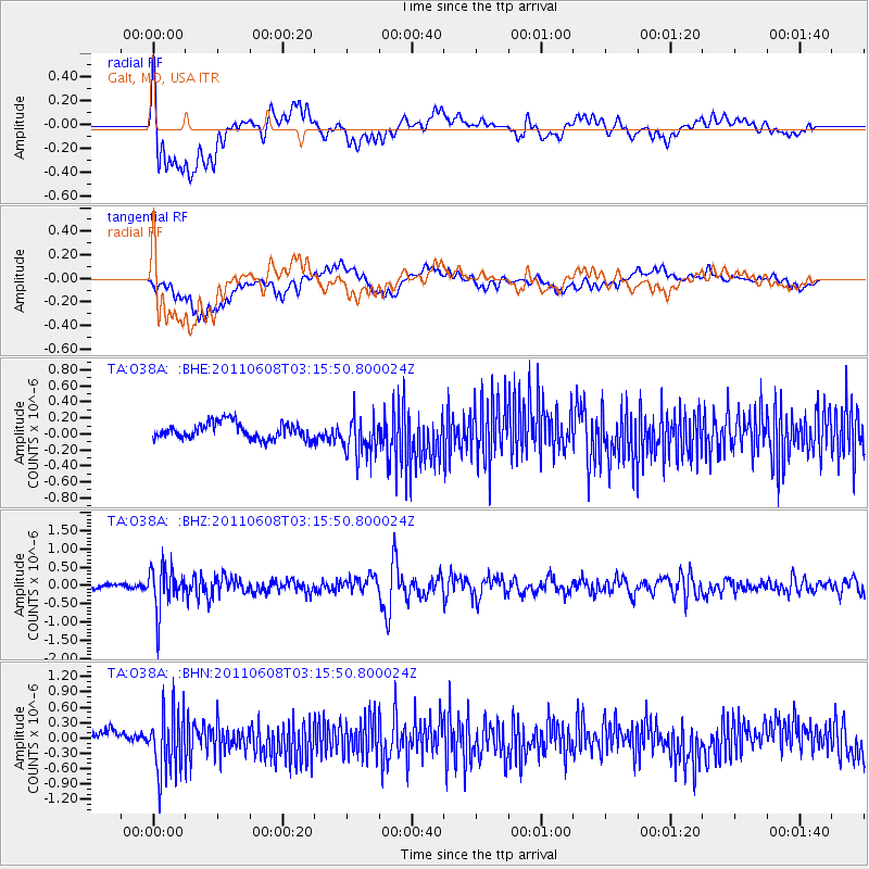
O38A Galt, MO, USA - Earthquake Result Viewer
*The percent match for this event was below the threshold and hence no stack was calculated.
| Earthquake location: |
Peru-Bolivia Border Region |
| Earthquake latitude/longitude: |
-17.1/-69.5 |
| Earthquake time(UTC): |
2011/06/08 (159) 03:06:22 GMT |
| Earthquake Depth: |
146 km |
| Earthquake Magnitude: |
5.8 MB, 5.9 MW, 5.9 MW |
| Earthquake Catalog/Contributor: |
WHDF/NEIC |
|
| Network: |
TA USArray Transportable Network (new EarthScope stations) |
| Station: |
O38A Galt, MO, USA |
| Lat/Lon: |
40.12 N/93.47 W |
| Elevation: |
266 m |
|
| Distance: |
61.1 deg |
| Az: |
339.174 deg |
| Baz: |
153.676 deg |
| Ray Param: |
$rayparam |
*The percent match for this event was below the threshold and hence was not used in the summary stack. |
|
| Radial Match: |
69.53843 % |
| Radial Bump: |
400 |
| Transverse Match: |
44.639072 % |
| Transverse Bump: |
400 |
| SOD ConfigId: |
394213 |
| Insert Time: |
2011-11-10 09:44:54.414 +0000 |
| GWidth: |
2.5 |
| Max Bumps: |
400 |
| Tol: |
0.001 |
|
Signal To Noise
| Channel | StoN | STA | LTA |
| TA:O38A: :BHZ:20110608T03:15:50.800024Z | 9.616406 | 5.831745E-7 | 6.06437E-8 |
| TA:O38A: :BHN:20110608T03:15:50.800024Z | 5.8603687 | 6.1796806E-7 | 1.0544866E-7 |
| TA:O38A: :BHE:20110608T03:15:50.800024Z | 2.4863968 | 2.5007668E-7 | 1.0057794E-7 |
| Arrivals |
| Ps | |
| PpPs | |
| PsPs/PpSs | |


