You are here: Home > Network List > TA - USArray Transportable Network (new EarthScope stations) Stations List
> Station O40A La Belle, MO, USA > Earthquake Result Viewer
O40A La Belle, MO, USA - Earthquake Result Viewer
| Earthquake location: |
Peru-Bolivia Border Region |
| Earthquake latitude/longitude: |
-17.1/-69.5 |
| Earthquake time(UTC): |
2011/06/08 (159) 03:06:22 GMT |
| Earthquake Depth: |
146 km |
| Earthquake Magnitude: |
5.8 MB, 5.9 MW, 5.9 MW |
| Earthquake Catalog/Contributor: |
WHDF/NEIC |
|
| Network: |
TA USArray Transportable Network (new EarthScope stations) |
| Station: |
O40A La Belle, MO, USA |
| Lat/Lon: |
40.12 N/91.87 W |
| Elevation: |
206 m |
|
| Distance: |
60.6 deg |
| Az: |
340.441 deg |
| Baz: |
155.319 deg |
| Ray Param: |
0.060978957 |
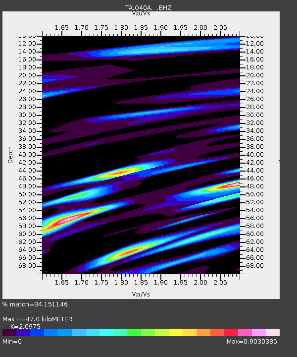
| Estimated Moho Depth: |
47.0 km |
| Estimated Crust Vp/Vs: |
2.10 |
| Assumed Crust Vp: |
6.498 km/s |
| Estimated Crust Vs: |
3.098 km/s |
| Estimated Crust Poisson's Ratio: |
0.35 |
|
| Radial Match: |
84.151146 % |
| Radial Bump: |
400 |
| Transverse Match: |
78.19319 % |
| Transverse Bump: |
400 |
| SOD ConfigId: |
394213 |
| Insert Time: |
2011-11-10 09:46:05.042 +0000 |
| GWidth: |
2.5 |
| Max Bumps: |
400 |
| Tol: |
0.001 |
|
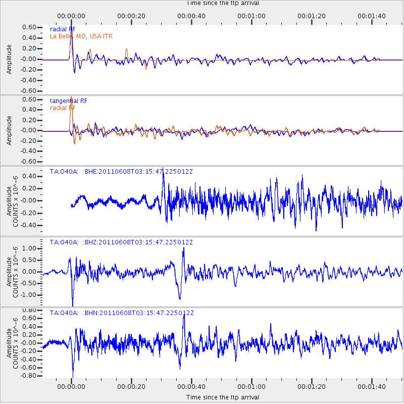
Signal To Noise
| Channel | StoN | STA | LTA |
| TA:O40A: :BHZ:20110608T03:15:47.225012Z | 8.777593 | 4.728564E-7 | 5.3870853E-8 |
| TA:O40A: :BHN:20110608T03:15:47.225012Z | 3.8290627 | 2.5951135E-7 | 6.777412E-8 |
| TA:O40A: :BHE:20110608T03:15:47.225012Z | 3.582834 | 1.8488569E-7 | 5.1603198E-8 |
| Arrivals |
| Ps | 8.3 SECOND |
| PpPs | 22 SECOND |
| PsPs/PpSs | 30 SECOND |


