You are here: Home > Network List > TA - USArray Transportable Network (new EarthScope stations) Stations List
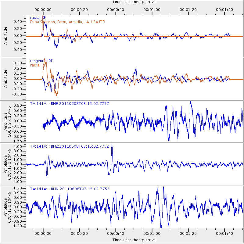
> Station 141A Papa Simpson, Farm, Arcadia, LA, USA > Earthquake Result Viewer
141A Papa Simpson, Farm, Arcadia, LA, USA - Earthquake Result Viewer
| Earthquake location: |
Peru-Bolivia Border Region |
| Earthquake latitude/longitude: |
-17.1/-69.5 |
| Earthquake time(UTC): |
2011/06/08 (159) 03:06:22 GMT |
| Earthquake Depth: |
146 km |
| Earthquake Magnitude: |
5.8 MB, 5.9 MW, 5.9 MW |
| Earthquake Catalog/Contributor: |
WHDF/NEIC |
|
| Network: |
TA USArray Transportable Network (new EarthScope stations) |
| Station: |
141A Papa Simpson, Farm, Arcadia, LA, USA |
| Lat/Lon: |
32.60 N/92.90 W |
| Elevation: |
91 m |
|
| Distance: |
54.2 deg |
| Az: |
335.615 deg |
| Baz: |
152.106 deg |
| Ray Param: |
0.06510039 |
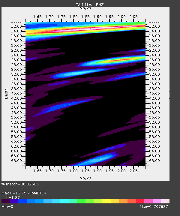
| Estimated Moho Depth: |
12.75 km |
| Estimated Crust Vp/Vs: |
1.87 |
| Assumed Crust Vp: |
6.245 km/s |
| Estimated Crust Vs: |
3.34 km/s |
| Estimated Crust Poisson's Ratio: |
0.30 |
|
| Radial Match: |
86.82605 % |
| Radial Bump: |
400 |
| Transverse Match: |
79.49947 % |
| Transverse Bump: |
400 |
| SOD ConfigId: |
394213 |
| Insert Time: |
2011-11-10 09:48:01.943 +0000 |
| GWidth: |
2.5 |
| Max Bumps: |
400 |
| Tol: |
0.001 |
|
Signal To Noise
| Channel | StoN | STA | LTA |
| TA:141A: :BHZ:20110608T03:15:02.775Z | 7.4980035 | 1.0460526E-6 | 1.3951082E-7 |
| TA:141A: :BHN:20110608T03:15:02.775Z | 1.6748297 | 2.6914054E-7 | 1.6069725E-7 |
| TA:141A: :BHE:20110608T03:15:02.775Z | 1.2246875 | 2.0860935E-7 | 1.7033682E-7 |
| Arrivals |
| Ps | 1.9 SECOND |
| PpPs | 5.6 SECOND |
| PsPs/PpSs | 7.5 SECOND |


