You are here: Home > Network List > TA - USArray Transportable Network (new EarthScope stations) Stations List
> Station Z48A Northport, AL, USA > Earthquake Result Viewer
Z48A Northport, AL, USA - Earthquake Result Viewer

| Earthquake location: |
Peru-Bolivia Border Region |
| Earthquake latitude/longitude: |
-17.1/-69.5 |
| Earthquake time(UTC): |
2011/06/08 (159) 03:06:22 GMT |
| Earthquake Depth: |
146 km |
| Earthquake Magnitude: |
5.8 MB, 5.9 MW, 5.9 MW |
| Earthquake Catalog/Contributor: |
WHDF/NEIC |
|
| Network: |
TA USArray Transportable Network (new EarthScope stations) |
| Station: |
Z48A Northport, AL, USA |
| Lat/Lon: |
33.38 N/87.56 W |
| Elevation: |
101 m |
|
| Distance: |
53.1 deg |
| Az: |
341.082 deg |
| Baz: |
158.249 deg |
| Ray Param: |
0.06585919 |
| Estimated Moho Depth: |
52.25 km |
| Estimated Crust Vp/Vs: |
1.69 |
| Assumed Crust Vp: |
6.565 km/s |
| Estimated Crust Vs: |
3.896 km/s |
| Estimated Crust Poisson's Ratio: |
0.23 |
|
| Radial Match: |
84.175835 % |
| Radial Bump: |
400 |
| Transverse Match: |
73.93934 % |
| Transverse Bump: |
400 |
| SOD ConfigId: |
394213 |
| Insert Time: |
2011-11-10 09:52:16.410 +0000 |
| GWidth: |
2.5 |
| Max Bumps: |
400 |
| Tol: |
0.001 |
|
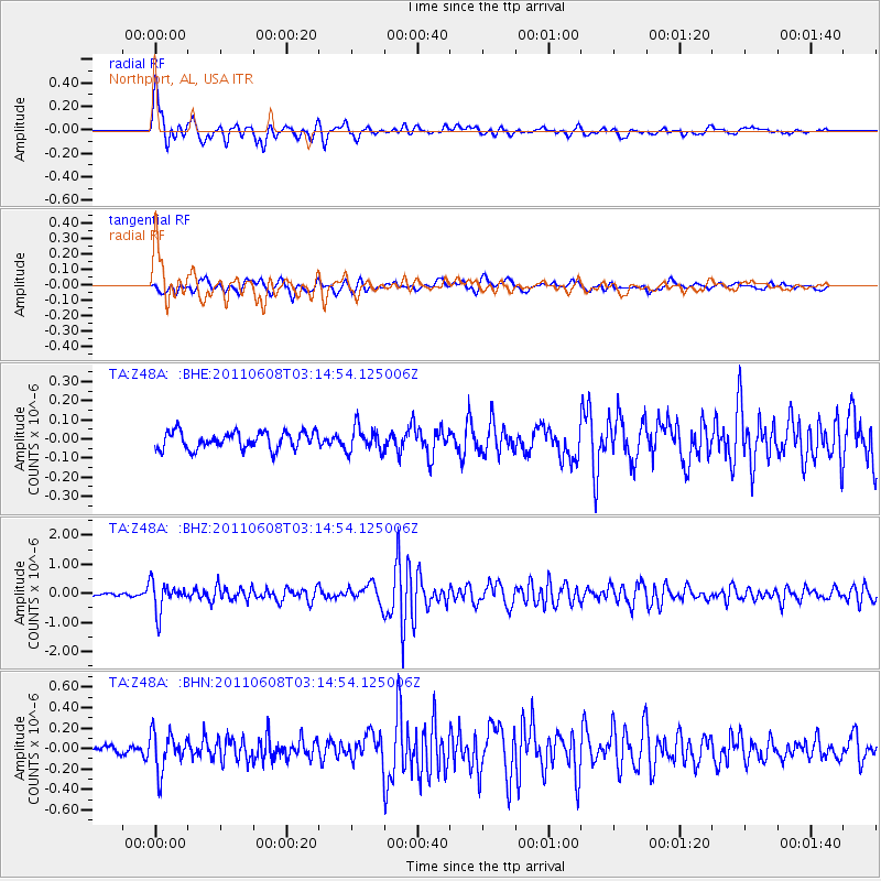
Signal To Noise
| Channel | StoN | STA | LTA |
| TA:Z48A: :BHZ:20110608T03:14:54.125006Z | 9.583852 | 5.059304E-7 | 5.278989E-8 |
| TA:Z48A: :BHN:20110608T03:14:54.125006Z | 4.119315 | 1.8482942E-7 | 4.4868965E-8 |
| TA:Z48A: :BHE:20110608T03:14:54.125006Z | 1.4480731 | 6.432279E-8 | 4.4419576E-8 |
| Arrivals |
| Ps | 5.8 SECOND |
| PpPs | 20 SECOND |
| PsPs/PpSs | 26 SECOND |


