You are here: Home > Network List > UW - Pacific Northwest Regional Seismic Network Stations List
> Station MRBL Marblemount, WA, USA > Earthquake Result Viewer
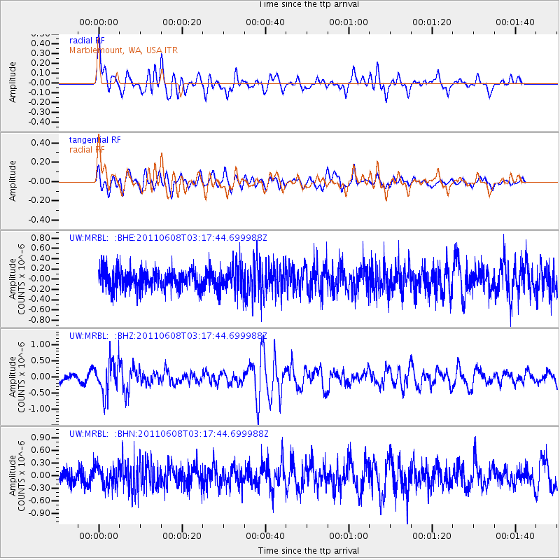
MRBL Marblemount, WA, USA - Earthquake Result Viewer
*The percent match for this event was below the threshold and hence no stack was calculated.
| Earthquake location: |
Peru-Bolivia Border Region |
| Earthquake latitude/longitude: |
-17.1/-69.5 |
| Earthquake time(UTC): |
2011/06/08 (159) 03:06:22 GMT |
| Earthquake Depth: |
146 km |
| Earthquake Magnitude: |
5.8 MB, 5.9 MW, 5.9 MW |
| Earthquake Catalog/Contributor: |
WHDF/NEIC |
|
| Network: |
UW Pacific Northwest Regional Seismic Network |
| Station: |
MRBL Marblemount, WA, USA |
| Lat/Lon: |
48.52 N/121.48 W |
| Elevation: |
75 m |
|
| Distance: |
80.0 deg |
| Az: |
327.875 deg |
| Baz: |
130.096 deg |
| Ray Param: |
$rayparam |
*The percent match for this event was below the threshold and hence was not used in the summary stack. |
|
| Radial Match: |
76.553856 % |
| Radial Bump: |
400 |
| Transverse Match: |
73.327614 % |
| Transverse Bump: |
400 |
| SOD ConfigId: |
394213 |
| Insert Time: |
2011-11-10 09:55:19.439 +0000 |
| GWidth: |
2.5 |
| Max Bumps: |
400 |
| Tol: |
0.001 |
|
Signal To Noise
| Channel | StoN | STA | LTA |
| UW:MRBL: :BHZ:20110608T03:17:44.699988Z | 3.7313676 | 5.0366054E-7 | 1.3498016E-7 |
| UW:MRBL: :BHN:20110608T03:17:44.699988Z | 1.4734776 | 2.4148653E-7 | 1.6388884E-7 |
| UW:MRBL: :BHE:20110608T03:17:44.699988Z | 1.4158926 | 2.5699532E-7 | 1.8150764E-7 |
| Arrivals |
| Ps | |
| PpPs | |
| PsPs/PpSs | |


