You are here: Home > Network List > CD - China Digital Seismograph Network Stations List
> Station LZH Lanzhou, Gansu Province, China > Earthquake Result Viewer
LZH Lanzhou, Gansu Province, China - Earthquake Result Viewer
| Earthquake location: |
Southeast Of Loyalty Islands |
| Earthquake latitude/longitude: |
-22.3/170.9 |
| Earthquake time(UTC): |
1998/01/04 (004) 06:11:58 GMT |
| Earthquake Depth: |
101 km |
| Earthquake Magnitude: |
6.4 MB, 7.4 UNKNOWN, 7.3 ME |
| Earthquake Catalog/Contributor: |
WHDF/NEIC |
|
| Network: |
CD China Digital Seismograph Network |
| Station: |
LZH Lanzhou, Gansu Province, China |
| Lat/Lon: |
36.09 N/103.84 E |
| Elevation: |
1560 m |
|
| Distance: |
85.9 deg |
| Az: |
311.594 deg |
| Baz: |
121.234 deg |
| Ray Param: |
0.044205356 |
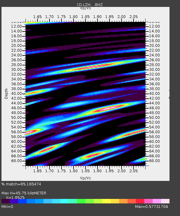
| Estimated Moho Depth: |
45.75 km |
| Estimated Crust Vp/Vs: |
1.95 |
| Assumed Crust Vp: |
6.306 km/s |
| Estimated Crust Vs: |
3.23 km/s |
| Estimated Crust Poisson's Ratio: |
0.32 |
|
| Radial Match: |
95.165474 % |
| Radial Bump: |
400 |
| Transverse Match: |
90.54254 % |
| Transverse Bump: |
400 |
| SOD ConfigId: |
4480 |
| Insert Time: |
2010-02-26 21:22:35.061 +0000 |
| GWidth: |
2.5 |
| Max Bumps: |
400 |
| Tol: |
0.001 |
|

Signal To Noise
| Channel | StoN | STA | LTA |
| CD:LZH: :BHZ:19980104T06:23:56.509009Z | 2.0260265 | 3.650685E-8 | 1.801894E-8 |
| CD:LZH: :BHN:19980104T06:23:56.509009Z | 0.7771642 | 2.4988681E-8 | 3.2153668E-8 |
| CD:LZH: :BHE:19980104T06:23:56.509009Z | 0.7438839 | 2.0108784E-8 | 2.7032154E-8 |
| Arrivals |
| Ps | 7.1 SECOND |
| PpPs | 21 SECOND |
| PsPs/PpSs | 28 SECOND |


