You are here: Home > Network List > IU - Global Seismograph Network (GSN - IRIS/USGS) Stations List
> Station TIXI Tiksi, Russia > Earthquake Result Viewer
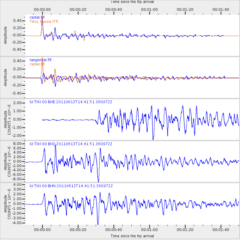
TIXI Tiksi, Russia - Earthquake Result Viewer

| Earthquake location: |
Northern Molucca Sea |
| Earthquake latitude/longitude: |
2.5/126.5 |
| Earthquake time(UTC): |
2011/06/13 (164) 14:31:22 GMT |
| Earthquake Depth: |
61 km |
| Earthquake Magnitude: |
6.4 MB, 6.4 MW, 6.4 MW |
| Earthquake Catalog/Contributor: |
WHDF/NEIC |
|
| Network: |
IU Global Seismograph Network (GSN - IRIS/USGS) |
| Station: |
TIXI Tiksi, Russia |
| Lat/Lon: |
71.63 N/128.87 E |
| Elevation: |
40 m |
|
| Distance: |
69.0 deg |
| Az: |
0.818 deg |
| Baz: |
182.578 deg |
| Ray Param: |
0.055777844 |
| Estimated Moho Depth: |
17.5 km |
| Estimated Crust Vp/Vs: |
1.79 |
| Assumed Crust Vp: |
6.552 km/s |
| Estimated Crust Vs: |
3.666 km/s |
| Estimated Crust Poisson's Ratio: |
0.27 |
|
| Radial Match: |
97.80062 % |
| Radial Bump: |
358 |
| Transverse Match: |
94.866066 % |
| Transverse Bump: |
400 |
| SOD ConfigId: |
395004 |
| Insert Time: |
2011-11-27 01:11:11.707 +0000 |
| GWidth: |
2.5 |
| Max Bumps: |
400 |
| Tol: |
0.001 |
|
Signal To Noise
| Channel | StoN | STA | LTA |
| IU:TIXI:00:BHZ:20110613T14:41:51.360972Z | 48.45982 | 2.8563131E-6 | 5.8941882E-8 |
| IU:TIXI:00:BHN:20110613T14:41:51.360972Z | 55.516365 | 1.1396875E-6 | 2.0528855E-8 |
| IU:TIXI:00:BHE:20110613T14:41:51.360972Z | 13.878324 | 4.3533055E-7 | 3.1367662E-8 |
| Arrivals |
| Ps | 2.2 SECOND |
| PpPs | 7.2 SECOND |
| PsPs/PpSs | 9.3 SECOND |


