You are here: Home > Network List > KN - Kyrgyz Seismic Telemetry Network Stations List
> Station USP KN.USP > Earthquake Result Viewer
USP KN.USP - Earthquake Result Viewer
| Earthquake location: |
Northern Molucca Sea |
| Earthquake latitude/longitude: |
2.5/126.5 |
| Earthquake time(UTC): |
2011/06/13 (164) 14:31:22 GMT |
| Earthquake Depth: |
61 km |
| Earthquake Magnitude: |
6.4 MB, 6.4 MW, 6.4 MW |
| Earthquake Catalog/Contributor: |
WHDF/NEIC |
|
| Network: |
KN Kyrgyz Seismic Telemetry Network |
| Station: |
USP KN.USP |
| Lat/Lon: |
43.27 N/74.50 E |
| Elevation: |
740 m |
|
| Distance: |
61.3 deg |
| Az: |
319.039 deg |
| Baz: |
116.286 deg |
| Ray Param: |
0.060786556 |
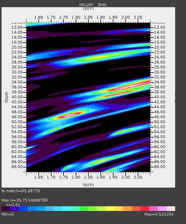
| Estimated Moho Depth: |
35.75 km |
| Estimated Crust Vp/Vs: |
2.01 |
| Assumed Crust Vp: |
6.306 km/s |
| Estimated Crust Vs: |
3.137 km/s |
| Estimated Crust Poisson's Ratio: |
0.34 |
|
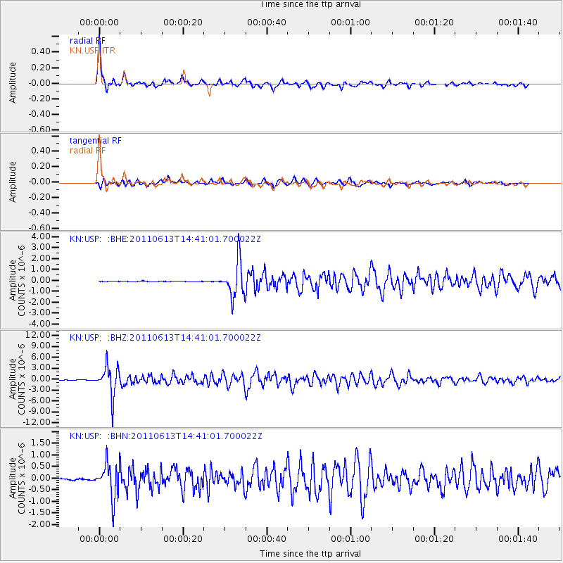
| Radial Match: |
95.69735 % |
| Radial Bump: |
398 |
| Transverse Match: |
89.42116 % |
| Transverse Bump: |
400 |
| SOD ConfigId: |
395004 |
| Insert Time: |
2011-11-27 01:11:46.243 +0000 |
| GWidth: |
2.5 |
| Max Bumps: |
400 |
| Tol: |
0.001 |
|
Signal To Noise
| Channel | StoN | STA | LTA |
| KN:USP: :BHZ:20110613T14:41:01.700022Z | 74.30948 | 4.1445783E-6 | 5.577456E-8 |
| KN:USP: :BHN:20110613T14:41:01.700022Z | 28.997946 | 7.573058E-7 | 2.6115845E-8 |
| KN:USP: :BHE:20110613T14:41:01.700022Z | 65.8399 | 1.6631536E-6 | 2.5260574E-8 |
| Arrivals |
| Ps | 5.9 SECOND |
| PpPs | 16 SECOND |
| PsPs/PpSs | 22 SECOND |


