You are here: Home > Network List > KN - Kyrgyz Seismic Telemetry Network Stations List
> Station KBK KN.KBK > Earthquake Result Viewer
KBK KN.KBK - Earthquake Result Viewer

| Earthquake location: |
Northern Molucca Sea |
| Earthquake latitude/longitude: |
2.5/126.5 |
| Earthquake time(UTC): |
2011/06/13 (164) 14:31:22 GMT |
| Earthquake Depth: |
61 km |
| Earthquake Magnitude: |
6.4 MB, 6.4 MW, 6.4 MW |
| Earthquake Catalog/Contributor: |
WHDF/NEIC |
|
| Network: |
KN Kyrgyz Seismic Telemetry Network |
| Station: |
KBK KN.KBK |
| Lat/Lon: |
42.66 N/74.95 E |
| Elevation: |
1760 m |
|
| Distance: |
60.8 deg |
| Az: |
318.58 deg |
| Baz: |
116.369 deg |
| Ray Param: |
0.06115366 |
| Estimated Moho Depth: |
10.25 km |
| Estimated Crust Vp/Vs: |
1.93 |
| Assumed Crust Vp: |
6.306 km/s |
| Estimated Crust Vs: |
3.263 km/s |
| Estimated Crust Poisson's Ratio: |
0.32 |
|
| Radial Match: |
92.61228 % |
| Radial Bump: |
400 |
| Transverse Match: |
86.26339 % |
| Transverse Bump: |
400 |
| SOD ConfigId: |
395004 |
| Insert Time: |
2011-11-27 01:12:10.685 +0000 |
| GWidth: |
2.5 |
| Max Bumps: |
400 |
| Tol: |
0.001 |
|
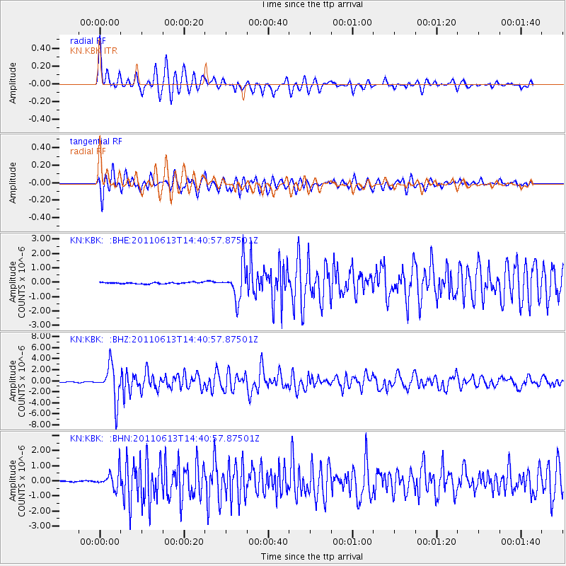
Signal To Noise
| Channel | StoN | STA | LTA |
| KN:KBK: :BHZ:20110613T14:40:57.87501Z | 67.839035 | 3.2843104E-6 | 4.8413284E-8 |
| KN:KBK: :BHN:20110613T14:40:57.87501Z | 14.892109 | 5.877142E-7 | 3.9464805E-8 |
| KN:KBK: :BHE:20110613T14:40:57.87501Z | 24.820517 | 1.2152663E-6 | 4.8962168E-8 |
| Arrivals |
| Ps | 1.6 SECOND |
| PpPs | 4.6 SECOND |
| PsPs/PpSs | 6.2 SECOND |


