You are here: Home > Network List > CN - Canadian National Seismograph Network Stations List
> Station INK INUVIK, NT > Earthquake Result Viewer
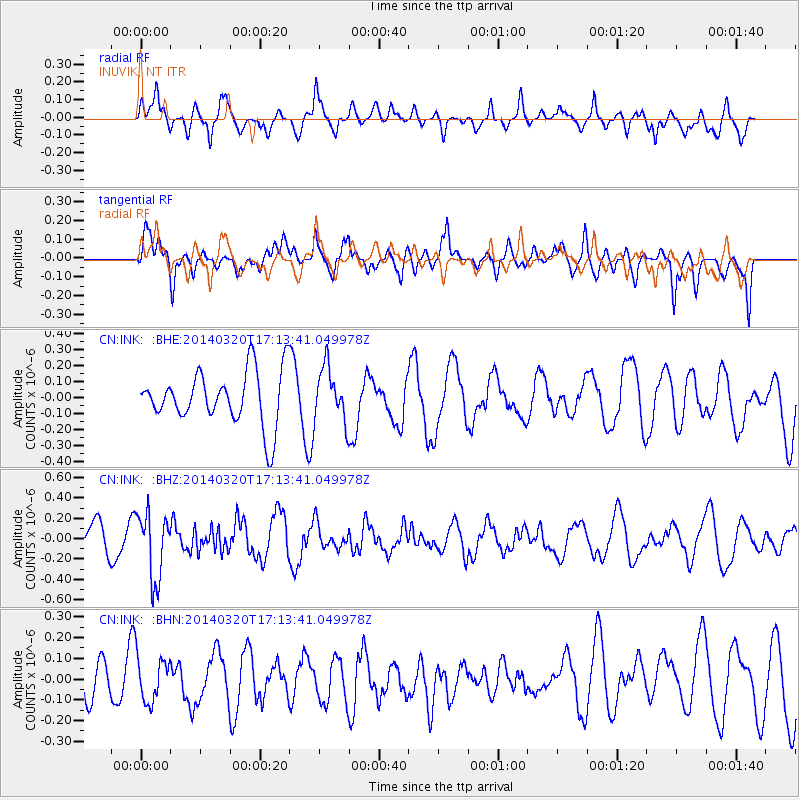
INK INUVIK, NT - Earthquake Result Viewer
*The percent match for this event was below the threshold and hence no stack was calculated.
| Earthquake location: |
New Britain Region, P.N.G. |
| Earthquake latitude/longitude: |
-5.2/152.9 |
| Earthquake time(UTC): |
2014/03/20 (079) 17:01:24 GMT |
| Earthquake Depth: |
53 km |
| Earthquake Magnitude: |
5.4 MW |
| Earthquake Catalog/Contributor: |
ISC/ISC |
|
| Network: |
CN Canadian National Seismograph Network |
| Station: |
INK INUVIK, NT |
| Lat/Lon: |
68.31 N/133.53 W |
| Elevation: |
44 m |
|
| Distance: |
88.8 deg |
| Az: |
20.902 deg |
| Baz: |
252.881 deg |
| Ray Param: |
$rayparam |
*The percent match for this event was below the threshold and hence was not used in the summary stack. |
|
| Radial Match: |
54.10959 % |
| Radial Bump: |
400 |
| Transverse Match: |
68.3447 % |
| Transverse Bump: |
400 |
| SOD ConfigId: |
3390531 |
| Insert Time: |
2019-04-10 18:50:50.020 +0000 |
| GWidth: |
2.5 |
| Max Bumps: |
400 |
| Tol: |
0.001 |
|
Signal To Noise
| Channel | StoN | STA | LTA |
| CN:INK: :BHZ:20140320T17:13:41.049978Z | 1.8382962 | 3.2224312E-7 | 1.7529445E-7 |
| CN:INK: :BHN:20140320T17:13:41.049978Z | 1.080266 | 1.0512074E-7 | 9.731006E-8 |
| CN:INK: :BHE:20140320T17:13:41.049978Z | 1.0088807 | 1.6922776E-7 | 1.6773812E-7 |
| Arrivals |
| Ps | |
| PpPs | |
| PsPs/PpSs | |


