You are here: Home > Network List > KN - Kyrgyz Seismic Telemetry Network Stations List
> Station UCH KN.UCH > Earthquake Result Viewer
UCH KN.UCH - Earthquake Result Viewer

| Earthquake location: |
Northern Molucca Sea |
| Earthquake latitude/longitude: |
2.5/126.5 |
| Earthquake time(UTC): |
2011/06/13 (164) 14:31:22 GMT |
| Earthquake Depth: |
61 km |
| Earthquake Magnitude: |
6.4 MB, 6.4 MW, 6.4 MW |
| Earthquake Catalog/Contributor: |
WHDF/NEIC |
|
| Network: |
KN Kyrgyz Seismic Telemetry Network |
| Station: |
UCH KN.UCH |
| Lat/Lon: |
42.23 N/74.51 E |
| Elevation: |
3850 m |
|
| Distance: |
60.9 deg |
| Az: |
317.978 deg |
| Baz: |
115.783 deg |
| Ray Param: |
0.06108747 |
| Estimated Moho Depth: |
21.5 km |
| Estimated Crust Vp/Vs: |
2.08 |
| Assumed Crust Vp: |
6.306 km/s |
| Estimated Crust Vs: |
3.039 km/s |
| Estimated Crust Poisson's Ratio: |
0.35 |
|
| Radial Match: |
96.8547 % |
| Radial Bump: |
318 |
| Transverse Match: |
91.120026 % |
| Transverse Bump: |
400 |
| SOD ConfigId: |
395004 |
| Insert Time: |
2011-11-27 01:12:17.326 +0000 |
| GWidth: |
2.5 |
| Max Bumps: |
400 |
| Tol: |
0.001 |
|
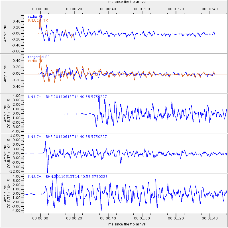
Signal To Noise
| Channel | StoN | STA | LTA |
| KN:UCH: :BHZ:20110613T14:40:58.575022Z | 60.481777 | 4.2986385E-6 | 7.107328E-8 |
| KN:UCH: :BHN:20110613T14:40:58.575022Z | 23.080784 | 9.80276E-7 | 4.247152E-8 |
| KN:UCH: :BHE:20110613T14:40:58.575022Z | 52.854633 | 1.6325031E-6 | 3.0886657E-8 |
| Arrivals |
| Ps | 3.8 SECOND |
| PpPs | 10 SECOND |
| PsPs/PpSs | 14 SECOND |


