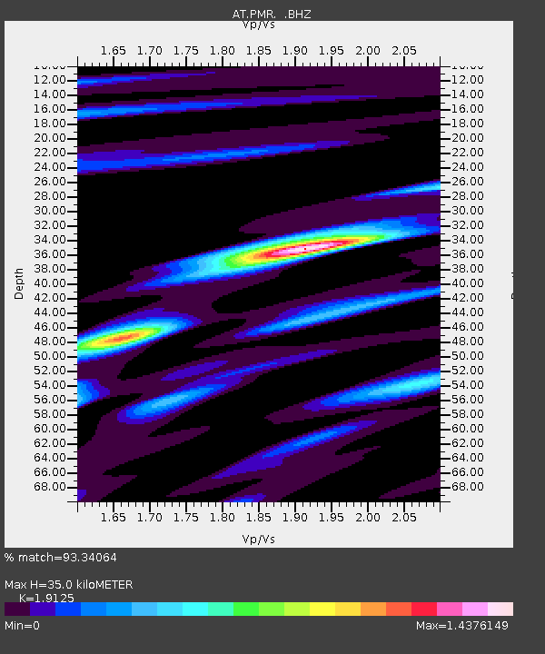
PMR Palmer, Alaska - Earthquake Result Viewer

Earthquake location: New Britain Region, P.N.G.
Earthquake latitude/longitude: -5.9/151.0
Earthquake time(UTC): 2011/06/16 (167) 00:03:35 GMT
Earthquake Depth: 16 km
Earthquake Magnitude: 6.1 MB, 6.5 MS, 6.3 MW, 6.2 MW
Earthquake Catalog/Contributor: WHDF/NEIC
Network: AT Alaska Tsunami Warning Seismic System
Station: PMR Palmer, Alaska
Lat/Lon: 61.59 N/149.13 W
Elevation: 100 m
Distance: 81.4 deg
Az: 24.715 deg
Baz: 240.421 deg
Ray Param: 0.047579456
Estimated Moho Depth: 35.0 km
Estimated Crust Vp/Vs: 1.91
Assumed Crust Vp: 6.566 km/s
Estimated Crust Vs: 3.433 km/s
Estimated Crust Poisson's Ratio: 0.31
Radial Match: 93.34064 %
Radial Bump: 400
Transverse Match: 83.22767 %
Transverse Bump: 400
SOD ConfigId: 395004
Insert Time: 2011-11-27 01:23:24.896 +0000
GWidth: 2.5
Max Bumps: 400
Tol: 0.001

Signal To Noise

ChannelStoNSTALTA
AT:PMR: :BHZ:20110616T00:15:20.480002Z13.0103928.8130844E-76.773881E-8
AT:PMR: :BHN:20110616T00:15:20.480002Z2.3337711.5152725E-76.492807E-8
AT:PMR: :BHE:20110616T00:15:20.480002Z8.0949474.4878047E-75.543958E-8
Arrivals
Ps5.0 SECOND
PpPs15 SECOND
PsPs/PpSs20 SECOND