You are here: Home > Network List > AZ - ANZA Regional Network Stations List
> Station SMER AZ.SMER > Earthquake Result Viewer
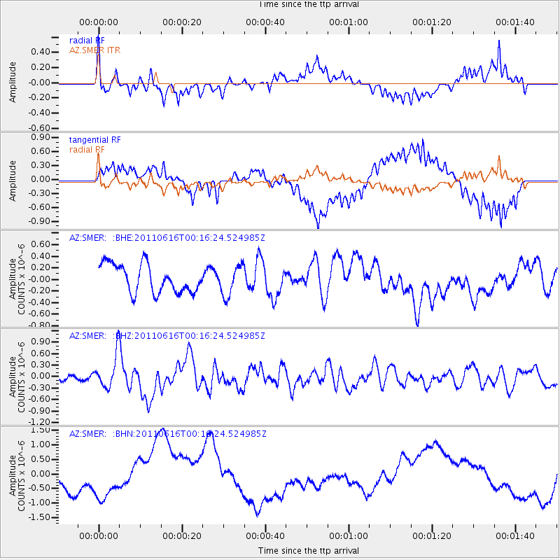
SMER AZ.SMER - Earthquake Result Viewer
*The percent match for this event was below the threshold and hence no stack was calculated.
| Earthquake location: |
New Britain Region, P.N.G. |
| Earthquake latitude/longitude: |
-5.9/151.0 |
| Earthquake time(UTC): |
2011/06/16 (167) 00:03:35 GMT |
| Earthquake Depth: |
16 km |
| Earthquake Magnitude: |
6.1 MB, 6.5 MS, 6.3 MW, 6.2 MW |
| Earthquake Catalog/Contributor: |
WHDF/NEIC |
|
| Network: |
AZ ANZA Regional Network |
| Station: |
SMER AZ.SMER |
| Lat/Lon: |
33.46 N/117.17 W |
| Elevation: |
355 m |
|
| Distance: |
94.7 deg |
| Az: |
56.974 deg |
| Baz: |
266.046 deg |
| Ray Param: |
$rayparam |
*The percent match for this event was below the threshold and hence was not used in the summary stack. |
|
| Radial Match: |
57.726597 % |
| Radial Bump: |
400 |
| Transverse Match: |
51.422806 % |
| Transverse Bump: |
400 |
| SOD ConfigId: |
395004 |
| Insert Time: |
2011-11-27 01:25:04.505 +0000 |
| GWidth: |
2.5 |
| Max Bumps: |
400 |
| Tol: |
0.001 |
|
Signal To Noise
| Channel | StoN | STA | LTA |
| AZ:SMER: :BHZ:20110616T00:16:24.524985Z | 6.819688 | 4.412818E-7 | 6.470704E-8 |
| AZ:SMER: :BHN:20110616T00:16:24.524985Z | 1.6780086 | 8.503858E-7 | 5.067828E-7 |
| AZ:SMER: :BHE:20110616T00:16:24.524985Z | 1.0813812 | 2.615812E-7 | 2.4189546E-7 |
| Arrivals |
| Ps | |
| PpPs | |
| PsPs/PpSs | |


