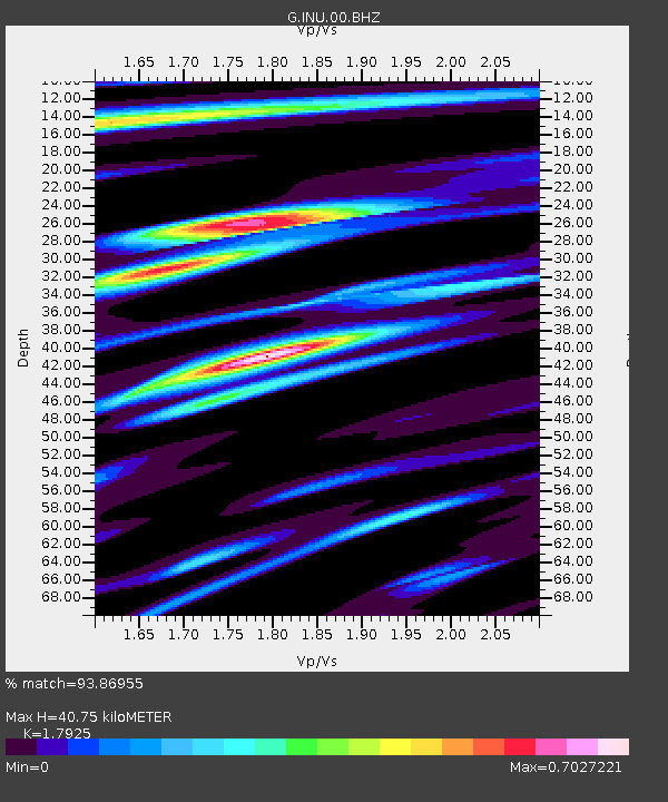
INU Inuyama, Japan - Earthquake Result Viewer

Earthquake location: New Britain Region, P.N.G.
Earthquake latitude/longitude: -5.9/151.0
Earthquake time(UTC): 2011/06/16 (167) 00:03:35 GMT
Earthquake Depth: 16 km
Earthquake Magnitude: 6.1 MB, 6.5 MS, 6.3 MW, 6.2 MW
Earthquake Catalog/Contributor: WHDF/NEIC
Network: G GEOSCOPE
Station: INU Inuyama, Japan
Lat/Lon: 35.35 N/137.03 E
Elevation: 132 m
Distance: 43.1 deg
Az: 343.171 deg
Baz: 159.372 deg
Ray Param: 0.07273737
Estimated Moho Depth: 40.75 km
Estimated Crust Vp/Vs: 1.79
Assumed Crust Vp: 6.461 km/s
Estimated Crust Vs: 3.605 km/s
Estimated Crust Poisson's Ratio: 0.27
Radial Match: 93.86955 %
Radial Bump: 363
Transverse Match: 75.92654 %
Transverse Bump: 400
SOD ConfigId: 395004
Insert Time: 2011-11-27 01:27:45.856 +0000
GWidth: 2.5
Max Bumps: 400
Tol: 0.001

Signal To Noise

ChannelStoNSTALTA
G:INU:00:BHZ:20110616T00:11:04.46099Z9.9064597.7709774E-77.844355E-8
G:INU:00:BHN:20110616T00:11:04.46099Z5.77266174.5415882E-77.867408E-8
G:INU:00:BHE:20110616T00:11:04.46099Z1.74685821.2234682E-77.0038205E-8
Arrivals
Ps5.3 SECOND
PpPs16 SECOND
PsPs/PpSs22 SECOND